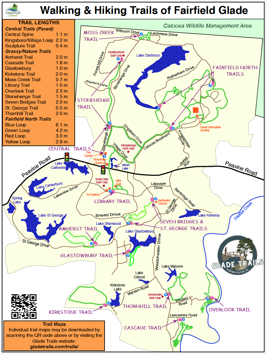
Hiking in Fairfield Glade
3. Trails of Fairfield glade
Our well-marked, well-maintained trails range from paved walking surfaces connecting most of Fairfield Glade’s amenities, to more challenging paths through enchanted looking forests. It is here that deer, eagles, and other wildlife mysteriously appear, providing photo opportunities along the way. Enjoy scenic mountain views, rocky cliffs, natural caves and winding creeks with seasonal whitewater.
It’s no wonder hiking has become one of Fairfield Glade’s most popular recreational activities.
You can find more about the trails in Fairfield Glade on their website at www.gladetrails.com
Table of Contents
- Amherst Trail, 2.0 miles, Easy
- Blue Hike, 6.1 miles, Strenuous
- Canyon Trail
- Cascade Trail, 2.3 miles, Moderate
- Central Trail, 1.9 miles, Easy
- Glastowbury Trail, 1.0 miles, Easy
- Good Samaritan Trail
- Green Hike, 4.2 miles, Strenuous
- Hemlock Trail
- Hickory Trail
- Kingsboro/Village Trail, 2.0 miles, Easy
- Kirkstone Trail, 2.0 miles, Moderate
- Library Trail, 1.0 miles, Easy
- McGinnis Trail
- Moss Creek Trail, 0.7 miles, Easy
- Overlook Trail, 2.3 miles, Moderate
- Red Hike, 3.0 miles, Strenuous
- Rotherham Trail
- Seven Bridges Trail, 2.0 miles, Moderate
- Seven Bridges and St George Trail, 2.5 miles, Moderate
- St George Trail, 0.5 miles, Moderate
- St George & Seven Bridges Trail, 2.0 miles, Moderate
- Stonehenge Trail, 3.0 miles, Moderate
- Thornhill Trail, 2.0 miles, Easy
- Yellow Hike, 2.9 miles, Strenuous
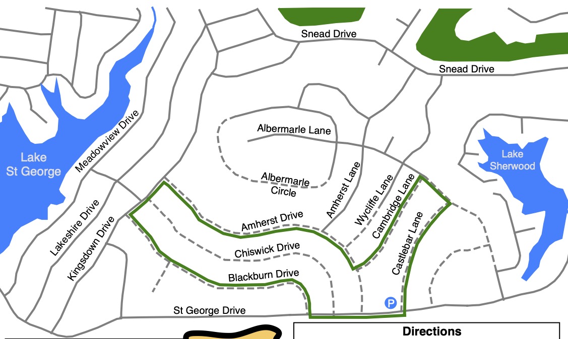
3.1 Amherst Trail
- Hiking Distance: 2.0 miles
- Trail Length: 2.0 miles
- Rating: Easy
- Trailhead GPS Coordinates: 35.984164, -84.891675
Trail Closed
due to construction on
St George Drive
Description
This is a 2.0-mile grassy road hiking trail located between St. George and Sherwood Lakes. This is an easy trail with very little change in elevation. Although most of the trail is on grassy roads, there are some sections along paved roads. There is limited parking just off St. George Drive on Castlebar Lane.
Driving Directions:
From the Peavine Road/Stonehenge Drive stoplight, take Peavine Road towards Crossville. Shortly after passing Food City turn left on to St. George Drive. After 2.25 miles (about one mile after passing Lake St. George) look for the trail sign on the left at the grassy road Castlebar Lane (first left past Amherst Drive). Park on the grassy road.
Most roads are unsigned so follow the trail posts and signs.
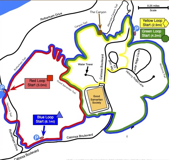
3.2 Blue Hike
- Hiking Distance: 6.1 miles
- Rating: Strenuous
- Trailhead GPS Coordinates: 36.017500, -84.863055
Description
The trailhead is the Catoosa/Kingsbridge parking lot on Catoosa Boulevard, but the trail can also be accessed via the Rotherham Drive or North Catoosa parking areas.
The Blue Loop is the longest hike in Fairfield Glade. It is comprised of four interconnected trails: the Hemlock Trail, the Rotherham Trail, the Canyon Trail, and the McGinnis Trail, along with a short segment of the Good Samaritan Trail.
This is a strenuous hike due to its length and the significant elevation changes along the way. The lowest point is at the end of Lake Dartmoor on Rotherham Drive. The highest point is at the top of the Rotherham Trail near the water tower. In addition there are two significant climbs on the McGinnis Trail.
Driving Directions
Take Peavine Road east and then turn north on to Catoosa Boulevard. After 1.0 mile turn left into the Catoosa/Kingsbridge parking lot marked with Nature Trail sign.
3.3 Canyon Trail
Description
The 1.4 mile Canyon Trail was completed in December 2013 but since then it has been incorpoated into the Blue, Green and Yellow hikes and is no longer considered a stand alone hiking trail.
3.4 Cascade Trail
- Hiking Distance: 2.3 miles
- Trail Length: 2.1 miles
- Rating: Moderate
- Trailhead GPS Coordinates: 35.960833, -84.860555
Driving Directions
From Peavine Road, turn onto Westchester Drive go 3.5 miles, passing the entrance to Dorchester Golf Club. Turn left on Lancashire Rd. (look for the Cascade Trail directional arrow). Proceed 0.3 miles to the third gravel/grass road on the right. Follow the sign to the gravel parking lot on the right. If the lot is full, park on the side of Lancashire Rd, leaving room for traffic to pass.
Description
By: Stella M. Gonzales-Woodworth
June 11, 2026
The Cascade Trail officially opened in the Summer of 2025, is one of Fairfield Glade’s most scenic and rewarding hiking experiences, offering visitors a journey through the rugged natural beauty of the Cumberland Plateau. Winding through a peaceful forest of hardwoods and pines, the trail showcases impressive rock formations, towering sandstone outcrops, and picturesque views that change with the seasons.
One of the trail’s most memorable highlights is the bluff overlook, where hikers are treated to sweeping views of the surrounding landscape and the winding corridor of Daddy’s Creek below. Just beneath the bluff lies a unique feature known as “The Squeeze”, a narrow passage between massive rock formations that adds a sense of adventure and wonder to the hike. The dramatic cliffs, weathered stone formations, and shaded creek valley create a landscape that feels both wild and timeless.
As the trail follows the edge of the gorge, hikers can enjoy the sights and sounds of Daddy’s Creek, whose waters have helped shape the area’s remarkable geology over thousands of years. Whether you’re drawn by the stunning overlooks, fascinating rock features, abundant wildlife, or the peaceful beauty of the forest, the Cascade Trail offers an unforgettable outdoor experience and a deeper appreciation for the natural wonders of Fairfield Glade.
During autumn, the Cascade Trail becomes one of the most spectacular hiking destinations in the region. The forest comes alive with brilliant shades of red, orange, gold and crimson as hardwoods blanket the landscape in vibrant fall color. From the bluff overlook, hikers can enjoy sweeping views of the surrounding hillsides painted with the rich hues of the season. Fallen leaves carpet the trail, while the crisp air and warm sunlight create ideal conditions for hiking, photography, and enjoying the beauty of the Cumberland Plateau at its peak.
Winter brings a different kind of beauty to the Cascade Trail. With the leaves gone from the trees, hikers are rewarded with expanded views of the rugged terrain, dramatic rock formations, and the Daddy’s Creek valley below. The trail’s towering sandstone cliffs and unique geological features become even more prominent against the stark winter landscape. On frosty mornings or after a light snowfall, the forest takes on a quiet, peaceful character, while sunlight filtering through the bare trees highlights the textures and colors of the ancient rock formations. The season offers a tranquil hiking experience and an opportunity to appreciate the trail’s natural beauty from a new perspective.
3.5 Central Trail
- Hiking Distance: 1.9 miles
- Trail Length: 1.9 miles
- Rating: Easy
- Street Address: 455 Lakeview Drive, Crossville, TN 38558
- Trailhead GPS Coordinates: 35.999882, -84.884157
Driving Directions
Approaching Fairfield Glade from Crossville turn right onto Snead Drive just after Weigel’s gas station. Take third turn on the left onto Lake View Drive.
Just Past the Druid Hills golf Club turn left at the stop sign. Turn left into the Fairfield Glade Library parking lot.
The street address of the library is 455 Lakeview Drive, Crossville, TN 38558
Description
By: Stella M. Gonzales-Woodworth, June 17, 2026
Winding gracefully through the heart of Fairfield Glade, the Central Trail offers one of the most enjoyable and picturesque walking experiences on Tennessee’s Cumberland Plateau. This beautifully maintained 4.6-mile network of interconnected paved pathways invites visitors to slow down, breathe deeply and discover the natural beauty and welcoming charm that make Fairfield Glade such a special place.
From the moment you step onto the trail, you’ll find yourself immersed in a landscape where nature and community blend seamlessly together. The smooth, fully paved surface makes every stroll effortless, whether you’re enjoying a leisurely walk, an energizing jog, biking, pushing a stroller, or taking your four-legged companion out for an adventure. With gentle terrain and easy accessibility, the trail welcomes visitors of all ages and abilities.
As the path meanders through the center of the Glade, you’ll cross quaint wooden bridges spanning sparkling creeks, wander beneath towering shade trees, and emerge into sunny open spaces where the beauty of the surrounding landscape unfolds around you. Each turn reveals something new – a peaceful woodland view, a colorful display of native wildflowers, or the soothing sound of flowing water.
One of the trail’s most treasured gems is Mirror Lake, a serene pond that reflects the sky like glass and provides a peaceful gathering place for both wildlife and visitors. Watch turtles sunning themselves along the shoreline, fish gliding beneath the water’s surface and an abundance of birds filling the air with song. Gentle streams flow from the lake, weaving through the landscape and creating a tranquil atmosphere that encourages you to linger and take it all in.
Beyond its natural beauty, the Central Trail serves as a scenic connector to many of Fairfield Glade’s favorite destinations. Along the way, you’ll find convenient access to neighborhoods, parks, and recreational amenities that define the community’s resort-style lifestyle. Nearby attractions include the renowned Stonehenge Golf Club, the Grille, the Druid Hills Recreation Area with its swimming pool and miniature golf course, art galleries, green market, and a variety of recreational opportunities that make every outing feel like a vacation.
Whether you’re seeking a peaceful morning walk, a refreshing afternoon escape, a place to connect with nature, or simply a beautiful route to explore the community, the Central Trail delivers an experience that is both relaxing and inspiring. It is more than just a path – it’s a journey through the very heart of Fairfield Glade, where every season brings new colors, new sights, and new reasons to return.
After an afternoon walk on Fridays and Mondays, summer nights at The Grove are the ultimate celebration of community, music and lakefront charm. Located right on the peaceful shores of Mirror Lake, this open-air ampitheater brings neighbors and families together for unforgettable evenings under trees. Mondays feature large, full-band concerts on the Main Stage, and dancing on the lawn is highly encouraged. The Friday night small stage shifted to relaxed, intimate acoustic night that brings fantastic country tributes, artists playing everything from soulful blues, bluegrass and jazz to heartfelt acoustic
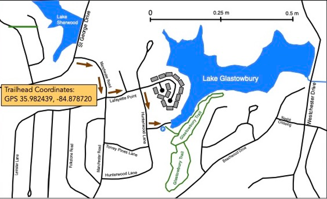
3.6 Glastowbury Trail
- Hiking Distance: 1.0 miles
- Trail Length: 0.9 miles
- Rating: Easy
- Trailhead GPS Coordinates: 35.982439, -84.878720
Driving Directions
From St George Drive take Manchester Road then turn left onto Lafayette Lane. Just before entering the condo complex, turn right onto Hunterwood Lane (Signed to the boat launch). Turn left to the boatlaunch and park at the trailhead.
Description
By: Stella M. Gonzales-Woodworth
June 14, 2026
Nestled along the shores of beautiful Glastowbury Lake in Fairfield Glade, Crossville, Tennessee, the Glastowbury Trail is proof that great things often come in small packages – a lakeside gem. This easy, one-mile trail may be short in distance, but it delivers an experience rich in natural beauty, peaceful scenery, and quiet moments that linger long after the hike is over.
The trail begins near the boat ramp at Glastowbury Lake. After crossing the wooden bridge, hikers can choose their adventure – follow the lakeside path to the left for continuous water views or venture right into the tranquil woodlands, before reconnecting with the shoreline. Either direction offers its own unique charm.
Throughout the walk, the mesmerizing waters of Glastowbury Lake remain the star attraction. The trail provides stunning views across the lake, where elegant homes reflect the area’s natural beauty and small boats rest quietly along the shoreline. The calm water, framed by trees and gentle hills, creates a scene of serenity that invites visitors to slow down, breathe deeply, and simply enjoy the moment.
Though considered an easy trail, Glastowbury features a gentle uphill climb, reaching its highest elevation of 1,844 feet. Along the way, thoughtfully placed benches offer welcome opportunities to rest and soak in the surroundings. One particular special bench, overlooking the lake from a scenic viewpoint known as Farpoint, is a favorite among hikers. Reached by a charming series of short stone steps, it provides a peaceful perch where visitors can sit quietly and admire the sparkling water and distant shoreline.
The trail also features a pleasant picnic area, perfect for enjoying a snack, sharing conversation with friends, or simply relaxing while taking in the beautiful lakeside setting. It is the kind of place where time seems to slowdown.
In many ways, Glastowbury Trail is like dessert after a wonderful meal – short, satisfying, and leaving you wanting just a little more. As you walk beside the lake, it is easy to imagine spending the afternoon boating across its calm waters, sipping something cold, enjoying a favorite treat, and basking in the warm Tennessee sunshine.
What makes this trail truly special is the way it combines woodland tranquility with ever-present lake views. Every turn offers another glimpse of Glastowbury Lake’s quiet beauty, creating a peaceful harmony between forest and water.
The trailhead may not be the easiest to find, but those who make the effort are richly rewarde. Whether you’re seeking a leisurely stroll, a scenic picnic spot, a place for reflection, or simply a beautiful walk in nature, Glastowbury Trail offers an unforgettable escape into one of Fairfield Glade’s most charming lakeside landscapes.
Come discover this hidden treasure and experience the beauty, tranquility, and timeless appeal of Glastowbury Lake – one peaceful step at a time.
3.7 Good Samaritan Trail
Description
The 1.0 mile Good Samaritan trail was completed in December 2013 but since then it has been incorpoated into the Red, Green and Yellow hikes and is no longer considered a stand alone hiking trail.
3.8 Green Hike
- Hiking Distance: 4.2 miles
- Rating: Strenuous
- Trailhead GPS Coordinates: 36.031447, -84.850316
Description
This loop takes you on three trails: the McGinnis Trail, the Good Samaritan Trail and the Canyon Trail. Most of the hike is on dirt trails in the woods but there is a short section on a paved sidewalk. The trail can be hiked in either the clockwise or counter-clockwise direction.
Driving Directions
From the junction of Peavine Road and Stonehenge Drive, take Peavine Road east for half a mile and turn left on to Catoosa Boulevard. After 2.8 miles turn into parking area on your right marked with a “Nature Trails” sign.
3.9 Hemlock Trail
Description
The Hemlock Trail is named for a majestic specimen hemlock tree that hikers will pass along the way. It was completed in October 2014. The trail now forms part of the Red Hike and Blue Hike.
3.10 Hickory Ridge Connector
Description
This 0.3 mile trail is part of the Yellow Hike.
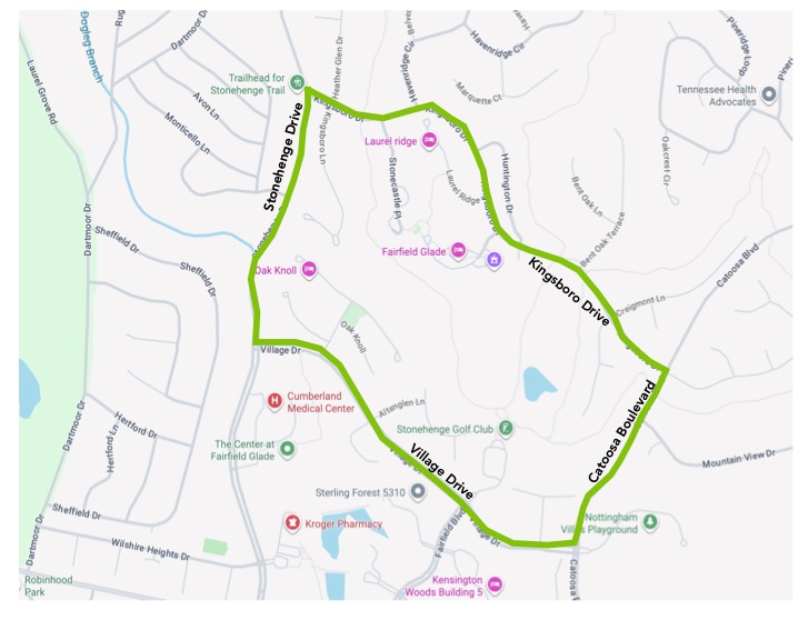
3.11 Kingsboro/Village Sidewalk
- Distance: 2.0 miles
- Rating: Easy
- Trailhead GPS Coordinates: 36.018751, -84.885131
Description
This is a pleasant walk along the sidewalks of four roads: Kingsboro Drive, Catoosa Boulevard, Village Drive and Stonehenge Drive.
Driving Directions
From the junction of Peavine Road and Stonehenge Drive, head north on Stonehenge Drive for 0.9 mile to the trail-head parking lot, on the left, at the corner of Kingsboro Drive.
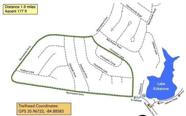
3.12 Kirkstone Trail
- Hiking Distance: 2.0 miles
- Trail Length 2.0 miles
- Rating: Moderate
- Trailhead GPS Coordinates: 35.967267, -84.887149
Description
This is approximately a 2.0 mile loop hiking trail along gravel roads. The trailhead is at the junction of Marmaduke and Christopher a little way up the hill from the spillway on Lake Kirkstone. The route is marked with yellow stakes and arrows at road junctions.
Starting at the trailhead, turn right on to Christopher Lane. At the end of Christopher Lane turn left onto Marmaduke Drive. Follow Marmaduke Drive for about 1.5 miles back the trailhead.
Driving Directions
From the junction of Peavine Road and Stonehenge Drive, take Peavine Road east for half a mile and turn right on to Westchester Drive. Follow Westchester Drive for 2.4 miles and turn right onto Malvern Rd. Follow Malvern Rd. for 0.9 miles and turn right on to Marmaduke Drive. Park at the corner of Marmaduke Drive and Oakburn Court.
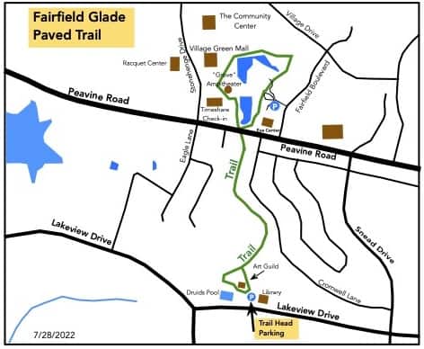
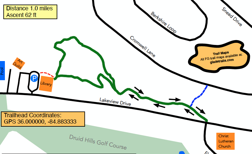
3.13 Library Trail
- Hiking Distance: 1.0 miles
- Trail Length: 1.0 miles
- Rating: Easy
- Trailhead GPS Coordinates: 36.000000, -84.883333
Description
This is a “lollipop” trail. Start out behind the library, going either direction along the loop. Travel down the “stick” to Lakeview Drive, then retrace your steps until you reach the loop once more. Complete the loop to return to your car. Extend your hike by either following the signs at Lakeview Drive to reach the Seven Bridges Trail, or by exiting the trail along the blue-blazed path to reach Cromwell Lane.
Driving Directions
From the junction of Peavine Road and Stonehenge Drive, take Peavine Road east for 0.5 miles (away from I-40) then turn right on Snead Drive. Travel about 0.5 miles then turn right on Lakeview Drive. Travel about 0.5 miles to the FG Library parking lot on the right.
Trailhead is behind and to the left of the library building, near the restrooms.
3.14 McGinnis Trail
The McGinnis trail was one of the first trails opened in Fairfield Glade, in May 2012. It has subsequently been included in the Blue and Green Hikes and is no longer considered a stand-alone trail.
3.15 Moss Creek Trail
- Hiking Distance: 0.7 miles
- Trail Length: 0.7 miles
- Rating: Easy
- Trailhead GPS Coordinates: 36.044526, -84.873841
Description
This is a neighborhood trail with limited parking at the trailhead at the end of Wibourne Drive. Because of the limited parking it will never be included in the Hiking Marathon.
Driving Directions
From the junction of Peavine Road and Stonehenge Drive, take Stonehenge Drive for about 2.5 miles and after the Heatherhurst Golf Club take the second left on to Forrest Hills Drive. Take the first right on to Wilbourne Drive and proceed to the end where you will find the trailhead.
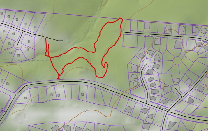
3.16 Overlook Trail
- Hiking Distance: 2.3 miles Outer Loop
- Hiking Distance: 1.3 miles South Loop
- Hiking Distance: 1.9 miles North Loop
- Trail Length: 2.4 miles
- Rating: Moderate
- Trailhead GPS Coordinates: 35.967933, -84.850431
Driving Directions
From the Peavine Road/Stonehenge Drive stoplight, take Peavine going east for half a mile. Turn right onto Westchester drive. After 3.0 miles, just after passing Dorchester Golf Club, turn left onto Windsor Road. Take the second right onto Wimberley Road then immediately turn left onto the gravel road. This road ends at the Overlook parking area and trailhead. After parking your vehicle and enjoying the views from the overlook enter the trail on the left.
Description
By: Stella M. Gonzales-Woodworth
June 14, 2026
The Windsor Bluff Overlook Trail as it is formally called, is one of the most beloved hiking destinations in Fairfield Glade, Crossville, Tennessee, offering a perfect combination of scenic beauty, peaceful woodland surroundings, and an invigorating hiking experience. Located near the Windsor Bluff Overlook, visitors can begin their adventure by stopping at the overlook itself to enjoy breathtaking views of the mountains and Daddy’s Creek Gorge before entering the trail.
From the overlook area, walk further a few meters on the left, and hikers have two route options. Turning left provides access to a 1.7 miles shorter loop, while heading right leads to a 2.3 miles longer route. Both trails intersect near Daddy’s Creek, creating either a 2.3-mile outer loop or a 2.8-miles figure-eight route. Designed in a lollipop configuration, the trail is known for its winding paths and varied terrain, featuring a mix of uphill climbs, downhill stretches, and level sections that keep the hike interesting from start to finish.
One of the trail highlights is its close connection to Daddy’s Creek. Throughout much of the hike, the soothing sound of flowing water accompanies visitors, creating a peaceful and relaxing atmosphere. In 2023, the trail was extended by 0.6 miles, adding a beautiful new section that showcases impressive rock work and provides even more scenic enjoyment for hikers.
Several benches are thoughtfully placed along the route, offering convenient spots to rest and take in the natural surroundings. A particularly inviting bench sits in front of a striking rock formation overlooking the creek, providing a wonderful place to pause and appreciate the beauty of both the rock features and the water below. Hikers will also encounter a wooden bridge that helps navigate one of the steeper sections of the trail, making the ascent and descent safer and more accessible.
The Windsor Bluff Overlook Trail is rich in both flora and fauna. Towering trees provide shade throughout much of the route, while abundant wildlife adds to the trail’s natural charm. Educational signs positioned along the path identify various medicinal herbs and native plants, offering visitors an opportunity to learn more about the area’s ecosystem as they hike.
Whether choosing the shorter loop or the longer figure-eight route, the Windsor Bluff Overlook Trail delivers a rewarding outdoor experience filled with scenic views, tranquil creekside moments, diverse terrain, and fascinating natural features. It is a trail that continues to captivate hikers and remains a favorite destination for those seeking both relaxation and adventure in the heart of Fairfield Glade.
3.17 Red Hike
- Hiking Distance: 3.0 miles
- Rating: Strenuous
- Trailhead GPS Coordinates: 36.024444, -84.868611
Description
We strongly recommend that you hike this loop in the counter-clockwise direction as this avoids climbing up the very steep Rotherham Trail. Follow the red hike markers.
Proceed along the end of the lake to the trailhead sign for the Hemlock Trail. Follow the trail, past the majestic hemlock tree for which the trail was named, and after half a mile cross Rotherham Drive. After another third of a mile the trail parallels Catoosa Boulevard for a quarter of a mile before turning back into the woods. From there, proceed behind Bluff View Terrace and climb upwards for nearly half a mile to the Good Samaritan Trail. Turn left and follow the trail behind the Preserve at Fairfield Glade (formerly the Good Samaritans) assisted living facility for a half a mile until you reach the intersection with the Rotherham Trail.
Turn left onto the Rotherham Trail and follow the trail as it descends steeply into the valley. After half a mile the trail turns left along the creek and levels out for an easy walk for the last half-mile to the Rotherham Drive parking lot where the hike started.
Driving Directions
From the junction of Peavine Road and Stonehenge Drive, take Peavine Road east for half a mile and turn left on to Catoosa Boulevard. After about 1.2 miles turn left on to Rotherham Drive. Drive down the steep hill and after 0.6 miles you will come to the parking lot on the left at the end of Lake Dartmoor.
Note: There is alternative parking available on Catoosa Boulevard at the junction with Kingsbridge Lane (Blue Hike Parking).
3.18 Rotherham Trail
The Rotherham Trail was one of the first trails opened in Fairfield Glade, in October 2013. It has subsequently been included in the Blue and Red Hikes and is no longer considered a stand-alone trail.
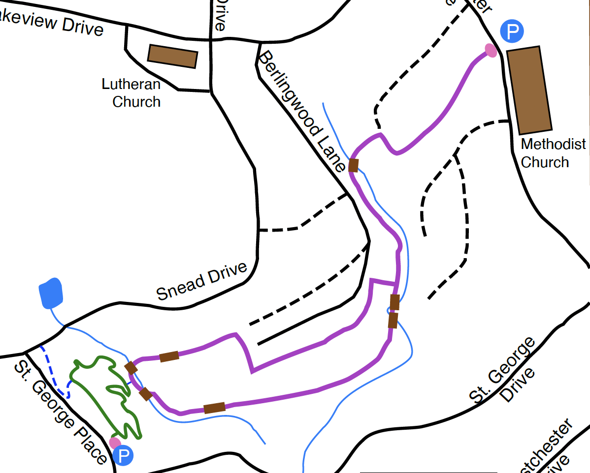
3.19 Seven Bridges Trail
- Hiking Distance: 2.0 miles
- Trail Length 2.0 miles
- Rating: Moderate
- Trailhead GPS Coordinates: 35.998370, -84.870564
Trail Description
This trail begins at the Methodist Church on Westchester Drive. It is a pleasant walk through the woods by a number of streams crossed by seven bridges. The trail is a lollipop configuration consisting of a half-mile stem and then a one-mile loop…return to the trailhead along the stem.
Driving Directions
From the junction of Peavine Road and Stonehenge Drive head east along Peavine Road for 0.5 miles. Turn right on to Westchester. Head south for 0.7 miles and pull into the first parking lot of the Methodist Church where trail parking is permitted. Cross the road to the trailhead.
Note: Please be considerate when parking in the Methodist Church parking lot, especially on Sunday mornings.
3.20 Seven Bridges & St George Trails
- Hiking Distance: 2.5 miles
- Rating: Moderate
- Trailhead GPS Coordinates: 35.998370, -84.870564
Description
This trail begins at the Methodist Church on Westchester Drive. It is a pleasant walk through the woods by a number of streams crossed by seven bridges. The trail is a lollipop configuration consisting of a half-mile stem and then a one-mile loop. Extend your hike by including the 0.5 mile St. George Trail loop. The short connector between the two trails is approximately halfway around the loop. Return and complete the Seven Bridges loop then return along the stem to the trailhead.
Driving Directions
From the junction of Peavine Road and Stonehenge Drive head east along Peavine Road for 0.5 miles. Turn right on to Westchester. Head south for 0.7 miles and pull into the first parking lot of the Methodist Church where trail parking is permitted. Cross the road to the trailhead.
Note: Please be considerate when parking in the Methodist Church parking lot, especially on Sunday mornings.
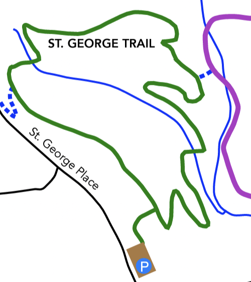
3.21 St George Trail
- Hiking Distance: 0.5 miles
- Trail Length: 0.5 miles
- Rating: Moderate
- Trailhead GPS Coordinates: 35.990278, -84.879722
Description
This short loop trail provides an extension to the popular Seven Bridges Trail. Neighborhood residents can walk to and access the trail via Snead Drive, while visitors can park at the trailhead on St. George Place.
Driving Directions
From Crossvillle, take Peavine Rd. going east. Turn right onto Westchester Dr. Continue 0.9 miles and turn right onto St. George Drive. In 0.2 miles, turn right onto St. George Place. The parking lot is on your right.
3.22 St George & Seven Bridges
- Hiking Distance: 2.0 miles
- Rating: Moderate
- Trailhead GPS Coordinates: 35.990278, -84.879722
Description
This short loop trail provides an extension to the popular Seven Bridges Trail. Neighborhood residents can walk to and access the trail via Snead Drive, while visitors can park at the trailhead on St. George Place.
Either way hikers can cross over and complete the Seven Bridges Loop before returning to complete the St George Trail.
Driving Directions
From Crossvillle, take Peavine Rd. going east. Turn right onto Westchester Dr. Continue 0.9 miles and turn right onto St. George Drive. In 0.2 miles, turn right onto St. George Place. The parking lot is on your right.
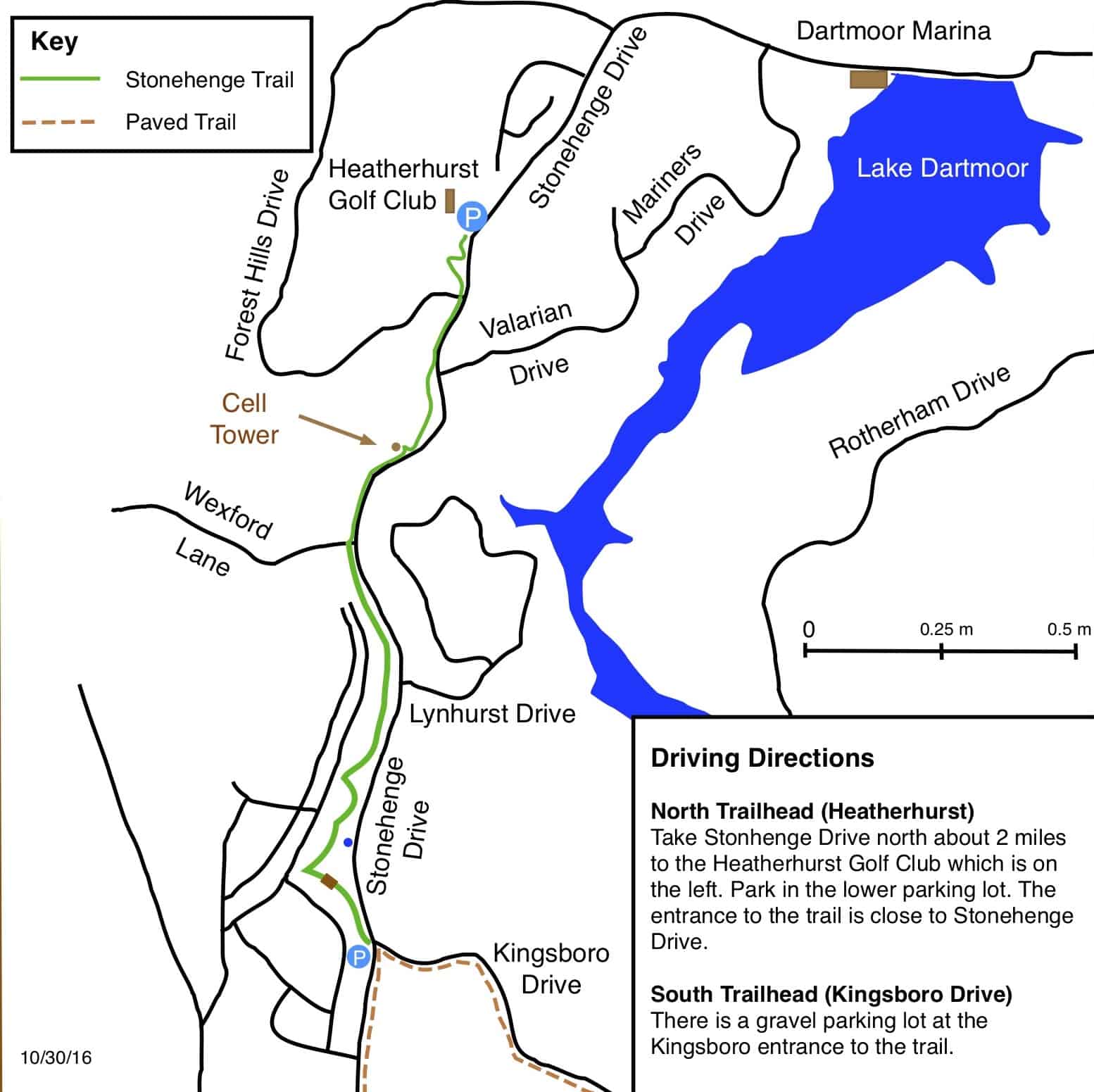
3.23 Stonehenge Trail
- Hiking Distance: 3.0 miles (round-trip)
- Trail Length: 1.5 miles
- Rating: Moderate
- Trailhead GPS Coordinates: 36.018751, -84.885131
Description
This is a 1.5-mile linear trail so the round-trip distance is 3.0 miles. The half-way point is the Heatherhurst golf club. The highest point of the trail is around the Lynhurst Drive area. Consequently it is a steady uphill climb from either end of the trail.
Driving Directions
From the junction of Peavine Road and Stonehenge Drive, head north on Stonehenge Drive for 0.9 mile to the trail-head parking lot, on the left, at the corner of Kingsboro Drive. If you prefer you can park at the Heatherhurst Golf Club lower parking lot and start your hike at the northern end of the trail.
3.24 Thornhill Trail
- Hiking Distance: 2.0 miles
- Trail Length: 2.0 miles
- Rating: Easy
- Trailhead GPS Coordinates: 35.970189, -84.865531
Description
The trailhead is in the parking lot of the Dorchester Golf Club. The trail starts by carefully crossing Westchester Drive onto Thornhill Lane. Most of the trail is on gravel/grassy roads that are unsigned so follow the trail posts and signs. It is worth taking a short detour on the dam of Lake Malvern to admire the view. The trail consists of flat roads. The biggest hazard is some deep ruts that fill with mud and water after heavy rains.
Driving Directions
From the Peavine Road and Stonehenge Drive stoplight, take Peavine Road east. After 0.5 miles turn right on to Westchester Drive. After 2.0 miles turn right into the Dorchester Golf Club parking lot. Park away from the clubhouse, near Westchester Drive at the trail-head
3.25 Yellow Hike
- Hiking Distance: 2.9 miles
- Rating Strenuous
- Trailhead GPS Coordinates: 36.031389, -84.850000
Description
This hike takes you through the Fairfield Glade canyon. The trail was extensively rerouted a few years ago due to the construction of new homes in the area. The new route is much more hiker-friendly than the old route and we are sure you will enjoy it.
Driving Directions
From the junction of Peavine Road and Stonehenge Drive, take Peavine Road east for half a mile and turn left on to Catoosa Boulevard. After 2.8 miles turn into parking area on your right marked with a “Nature Trails” sign.