hiking along the Cumberland Trail (draft)
4. The Cumberland Trail in Cumberland County
There are over 40 miles of the Cumberland Trail in Cumberland County. The trail segments are generally described here from north to south with section 4.1 starting at the Devil’s Breakfast Table and section 4.8 ending at the Head of Sequatchie (HoS). Some of the descriptions are south to north to give a choice of shorter and longer hikes from the available trailheads.
Table of Contents
Northern Section: Devil's Breakfast Table Trailhead to. the Powerlines Trailhead
- (4.1) Devil’s Breakfast Table to Peavine,
15.2 miles round trip, Strenuous - (4.1.1) Devil’s Breakfast Table to McGinnis Creek Bridge, 10.8 miles round trip, Srenuous
- (4.1.2) Peavine Road to McGinnis Creek, 4.4 miles , Moderate
- (4.2) Peavine Road Trailhead to Yellow Gate Trailhead, 12.6 miles round trip, Moderate
- (4.2.1) Peavine Road to Future Bridge over Daddy’s Creek, 7.4 miles round trip, Moderate
- (4.2.2) Daddy’s Creek Bridge to Yellow Gate Trailhead, 5.2 miles round trip, Moderate
- (4.3) Yellow Gate Trailhead to Power Lines, 5.6 miles round trip, Moderate
- (4.3.1) Yellow Gate Trailhead to De Lozier Bridge, 3.6 miles roundtrip, Moderate
- (4.3.2) Power Lines parking to De Lozier Bridge, 2.0 miles round trip, Moderate
Southern Section: Power Lines Trailhead to the Head of Sequatchie
- (4.4) Power Lines To Ozone Falls, 8.0 miles by road
- (4.5) Ozone Falls to Black Mountain Summit, 13.4 miles round trip, Strenuous
- (4.6) Black Mountain summit to Hwy 68, 6.8 miles round trip, Moderate
- (4.6.1) Black Mountain Summit to Windlass Cave, 3.8 miles round trip, Moderate
- (4.6.2) Hwy 68 to Windlass Cave, 3 miles round trip, Moderate
- (4.7) Hwy 68 to Jewitt Rd (Brady Mt), 15 miles round trip, Strenuous
- (4.8) Jewitt Road to HoS Trailhead, 2 miles round trip, Moderate
Northern Section

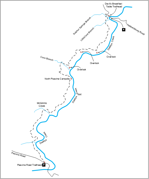
This is the official map of the Cumberland Trail in the northern part of Cumberland County: From Devil’s Breakfast Table to the Daddy’s Creek Trailhead(Yellow Gate).
(4.9) Additional Hiking Sections
- (4.9.1) Peavine Road to Whiteoak Branch Bridge, 2.6 miles round trip, Moderate
- (4.9.2) E. Keyes Road to Daddy’s Creek Suspension Bridge, 4.4 miles round trip, Moderate
- (4.9.3) Peavine Road to E. Keys Road (by road), 1.8 miles
- (4.9.4) Ozone Falls Trail, 2 miles round trip, Strenuous
- (4.9.5) Black Mountain Summit Loop, 2 miles, Easy
- (4.9.6) Black Mountain Below the Bluffs, 1.0 miles round trip, Easy
- (4.9.7) Head of Sequatchie: Selby Loop + Devil Step Cave, 1.6 miles, Moderate
- (4.9.8) Peavine Road to FG Overlook Trailhead, 4.6 miles one way, Moderate
- (4.9.9) E. Keyes Road to Yellow Gate Parking, 9.6 miles round trip, Moderate
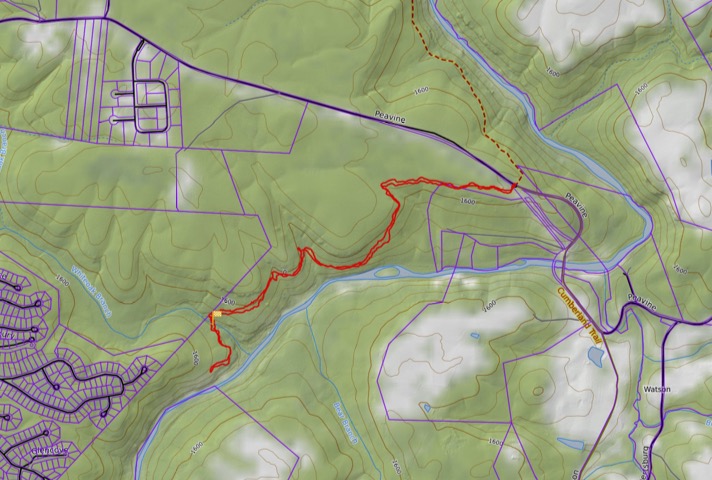
4.1 Devil's Breakfast Table to Peavine Road
- Hiking Distance: 15.2 miles round trip
- Trail Length: 7.6 miles
- Rating: Strenuous
- Trailhead GPS Coordinates: N36°03.523 W84°47.548
Trail Description
Many of these trail descriptions and maps were obtained from the Cumberland Trail Conservancy website.
Hikers must wear florescent clothing to maintain visibility to hunters in the area during hunting seasons.
Devils Breakfast Table Trailhead. Trailhead for the Obed Wild and Scenic River Segment is about 200 feet up the gravel road east of Daddys Creek bridge on the left. The trail with two big boulders across from the parking area is not the CT. This area is also popular with people swimming and fishing during the summer months.
(North to South) This trail is 7.6 miles one way and travels much of the way on the bluff top above Daddys Creek.
From the northern terminus trailhead the trail drops down crossing Sulphur Springs Branch on a wooden bridge. The trail than climbs up onto a ridge where there are three dramatic overlooks before the trail dips down to Cove Branch and then the backcountry campsite. The Little Cove Branch is next to an impressive rockhouse bluff and is bridged by an aluminum bridge. The trail then climbs out of the cove to a ridge which it follows to to the wooden bridge crossing McGinnis Creek. It is 0.9 miles from Cove Branch to McGinnis
Get more information from the Cumberland Trail Conservancy website:
Driving Directions
The northern end of this Section can be reached by entering the Catoosa WMA on Firetower Road. Take I-40 Exit 322, go north on Peavine Road/101 North for 1.8 miles to Firetower Road. Turn left on Firetower Road where you will see the high voltage power lines on your left. Firetower Road is a paved road for 3.5 miles and then becomes packed gravel when you approach the Catoosa WMA entry. The main roads in the Catoosa are graveled but suitable for passenger cars. Proceed another 11 miles after entering the WMA to Daddys Creek and the Devil’s Breakfast Table. (Note: Fire Tower Road turns into Otter Creek Road shortly after entering Catoosa WMA). Cross a sturdy 120-foot one-lane bridge with wood decking and no guardrails over Daddys Creek. Graveled parking is on the right with room for about a dozen vehicles at Devil’s Breakfast Table trailhead.
4.1.1 Devil's Breakfast Table to McGinnis Creek Bridge
- Hiking Distance: 10.8 miles round trip
- Trail Distance: 5.4 miles
- Rating: Strenuous
- Trailhead GPS Coordinates: N36°03.523 W84°47.548
Description
Follow the trail description from the previous section (4.1) from Devil’s Breakfast Table to McGinnis Creek.
The southern end of this hike is the wooden bridge crossing McGinnis Creek at N36.020762, W-84.823291
Driving Directions
The northern end of this Section can be reached by entering the Catoosa WMA on Firetower Road. Take I-40 Exit 322, go north on Peavine Road/101 North for 1.8 miles to Firetower Road. Turn left on Firetower Road where you will see the high voltage power lines on your left. Firetower Road is a paved road for 3.5 miles and then becomes packed gravel when you approach the Catoosa WMA entry. The main roads in the Catoosa are graveled but suitable for passenger cars. Proceed another 11 miles after entering the WMA to Daddys Creek and the Devil’s Breakfast Table. (Note: Fire Tower Road turns into Otter Creek Road shortly after entering Catoosa WMA). Cross a sturdy 120-foot one-lane bridge with wood decking and no guardrails over Daddys Creek. Graveled parking is on the right with room for about a dozen vehicles at Devil’s Breakfast Table trailhead.
4.1.2 Peavine Road to McGinnis Creek
- Hiking Distance: 4.4 miles round-trip
- Trail Length: 2.2 miles
- Rating: Moderate
- Trailhead GPS Coordinates: 36.000824, -84.825522
Trail Description
(South to North) This hike allows people to explore a section of the Devil’s Breakfast Table section without committing to the full 7.6 miles and a vehicle shuttle.
From the parking area on Peavine Road, start at the trailhead kiosk on the north side of Peavine road. The kiosk provides a nice topo map of the trail. The trail starts along the bluff top on fairly level and smooth terrain through hardwoods.
After 0.7 miles cross an unnamed branch on a wooden bridge.
After 1.3 miles the trail crosses an old gravel logging road. Large arrowed blazes direct you straight across the roadbed.
After 2.2 miles you reach the wooden bridge over McGinnis Creek. Stop, rest, have a drink, enjoy the rocks and vegetation, and then retrace your steps back to your vehicle.
Driving Directions
This trailhead is exactly 3.0 miles from the corner of Peavine Road and Catoosa Blvd, (and Westchester Dr.) on Peavine Road in Fairfield Glade. Park on the right side of the road across from the trailhead
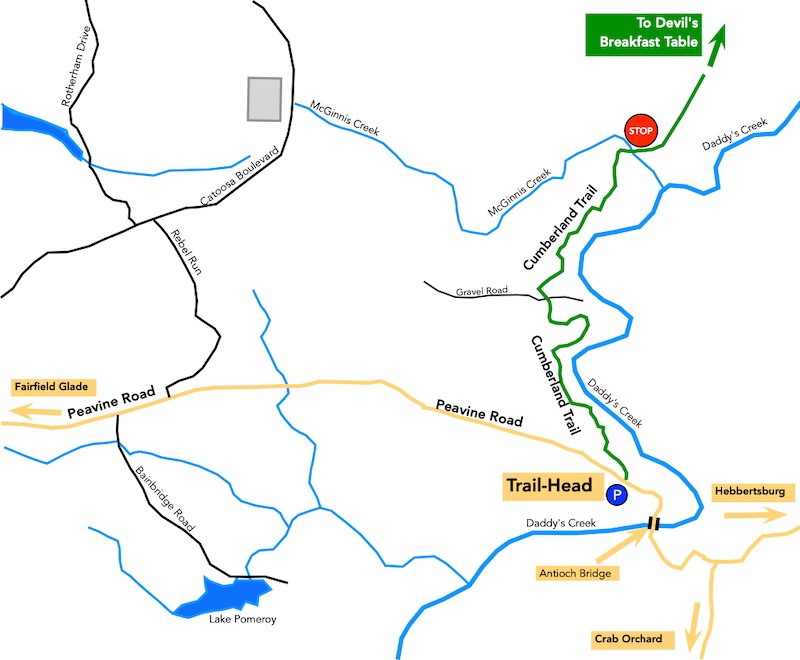
4.2 Peavine Road Trailhead to Daddy's Creek Trailhead (Yellow Gate Parking)
- Hiking Distance: 12.6 miles round trip
- Trail Length: 6.3 miles
- Rating: Moderate
- Trailhead GPS Coordinates:
Description
Note: This hike requires crossing Daddy’s Creek by a low-water crossing until the suspension bridge is built.
Note 1: Take care that you take the trail south. Do not head north towards the Devil’s Breakfast Table. That is the wrong direction. Stop and turnaround!
This is a new trail constructed in the summer of 2025. The first half mile is easy with very little change in elevation. The second half mile is a little more challenging with some elevation changes and rock steps.
The third half mile is even more challenging with significant elevation and many large rock steps.
At this point you will come to a large metal bridge over Whiteoak Branch Creek.
Continue following the trail to the end where eventually a bridge across Daddy’s Creek will be built.
The proposesed bridge location is
35.97408, -84.84814. or
35°58’26.7″N 84°50’53.3″W
If the water level is low and it is safe to do so, cross Daddy’s Creek and rejoin the Cumberland Trail on the far side of the creek. Head south along the trail (Upstream) for half a mile or so along the bank of the creek before starting the climb out of the river valley. Take the short spur to admire the view from the overlook. Continue along the trail , taking the short connector trail to the Daddy’s Creek Trailhead (Yellow Gate parking area.)
Driving Directions
This trailhead is about 3.5 miles from the corner of Peavine Road and Stonehenge Drive (the last stop light) on Peavine Road in Fairfield Glade, heading away from Crossville, towards Hebbertsburg.
The trailhead parking is located on the right hand side of the road. It is not a parking lot, just pull-off at the side of the road. Do not cross the road. The trail entrance is on the same side of the road as the parking area.

4.2.1 Peavine Road to Future Bridge over Daddy's Creek
- Hiking Distance: 7.4 miles round trip
- Trail Length: 3.7 miles
- Rating: Moderate
- Trailhead GPS Coordinates: 36.000824, -84.825522
Trail Description
Note 1: Take care that you take the trail south. Do not head north towards the Devil’s Breakfast Table. That is the wrong direction. Stop and turnaround!
This is a new trail constructed in the summer of 2025. The first half mile is easy with very little change in elevation. The second half mile is a little more challenging with some elevation changes and rock steps.
The third half mile is even more challenging with significant elevation and many large rock steps.
At this point you will come to a large metal bridge over Whiteoak Branch Creek.
Continue following the trail to the end where eventually a bridge across Daddy’s Creek will be built.
You can continue along an old logging road an connect with the Fairfield Glade Overlook Trail or you can retrace your steps to your vehicle.
Driving Directions
This trailhead is about 3.5 miles from the corner of Peavine Road and Stonehenge Drive (the last stop light) on Peavine Road in Fairfield Glade, heading away from Crossville, towards Hebbertsburg.
The trailhead parking is located on the right hand side of the road. It is not a parking lot, just pull-off at the side of the road. Do not cross the road. The trail entrance is on the same side of the road as the parking area.

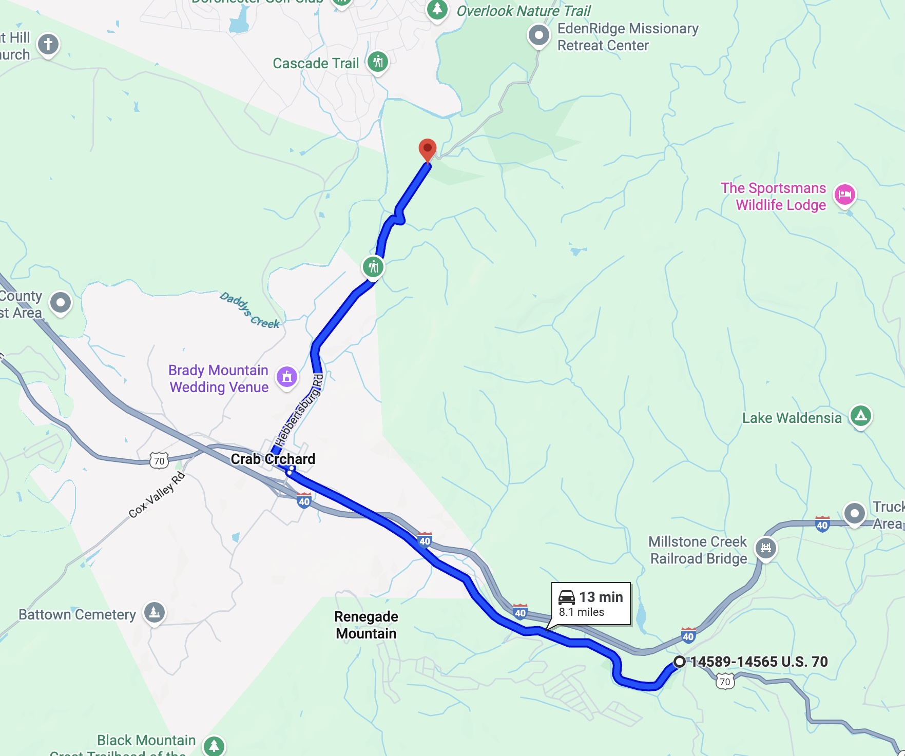
4.2.2 Daddy's Creek Bridge to Daddy's Creek Trailhead (Yellow Gate Parking)
- Hiking Distance: 5.2 miles round trip
- Trail Length: 2.6 miles
- Rating: Moderate
- Trailhead GPS Coordinates: 35°56'55.8"N 84°51'08.1"W
Driving Directions
From East or West, take I40 Exit 329, Crab Orchard. From East, turn right; from West turn left toward the little town of Crab Orchard. Cross US 70 and the railroad track. Turn left on Main Street. In a short distance turn right on Hebbertsburg Road. Take Hebbertsburg Road North for x.x miles to the Yellow Gate parking area at the Daddy’s Creek Trailhead. The trailhead is located on the left, just past the entrance to the EdenRidge Missionary Retreat on the right.
Trail Description (South to North
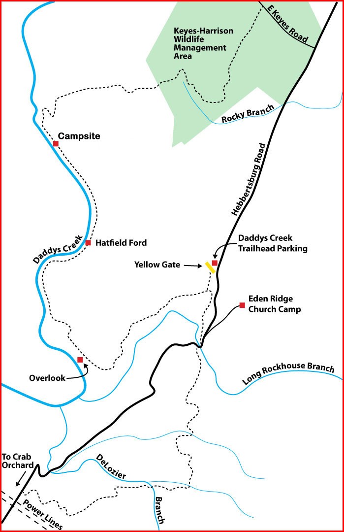
The trailhead is 150 feet from Hebbertsburg Road on the left just beyond the yellow gate. This connector with yellow blazes passes through scrub mixed forest of recent growth for 865 feet before intersecting the main trail. At all times of year both open field and forest birds can be seen and heard due to the open canopy.
At the junction, notice the sign indicating the main trail direction North to the Overlook, Campsite, and Keyes Road and South to Hebbertsburg Road. The sign misspells Hebbertsburg. Turn right heading northerly toward East Keyes Road.
The trail begins a short gentle descent. The forest here is mostly hardwood recent growth. The trail begins a gentle undulating descent through mountain laurel and mixed forest. Cross a small wet weather drainage. Continue through a nice white pine glade. The trail begins to descend. Switchback up stone steps and shortly climb stone steps between two large white pine trees.
Cross a wet weather drainage as the trail meanders through mixed scrub forest. Notice the large colonies of ground pine through the next 0.10 mile. Overlook spur. A short 125 foot spur trail on the left leads to an overlook with splendid views south up Daddys Creek Gorge and its mixed forest below. The fall colors can be spectacular and winter views without foliage provide an expansive look at the gorge. This is also a good spot for birders who want to glimpse raptors in flight. (El. 1,712′) N35 57.97, W84 50 33.41
From the overlook spur, the trail begins a steady gentle descent into Daddys Creek Gorge. Cross a large wet weather drainage with stones for fording. Notice the small stone shelf on the right. Note the thin sedimentary layers visible in the rocks on the right before descending on stone steps. The trail veers away from Daddys Creek below to the left and leaves the older growth forest with its larger trees and then continues to descend into Daddys Creek Gorge. The trail passes rhododendron thickets on the right. Dense rhododendron thickets are called “hells” because they are so difficult to penetrate. The trail begins its final undulating descent before leveling out in the gorge. Trail joins Daddys Creek at N35 43.85, W84 51 00.28. Elevation 1,542′.
For the next .9 mile, the trail follows Daddys Creek on the left through generally level terrain. Note that Daddys Creek flows north. There are stands of hemlock, white pine, rhododendron and mountain laurel as well as mixed hardwoods. There are interesting rock bluffs on the right along the way. The trail crosses Hatfield Branch which runs most of the time except in dry seasons. Just before the crossing there is a rock bluff on the right as you cross a drainage on stone steps. This bluff weeps water all year and is known as the “Billboard” because it can be seen from the Fairfield Glade Overlook Trail across the creek.
Wave to the hikers on the other side of Daddys Creek. Also note the fairly good sized large leaf magnolia on the left in this area. Magnolia Macrophylla, the “large leaf magnolia”, is a deciduous magnolia native to the southeastern United States and eastern Mexico. It boasts the largest simple leaf and single flower of any native plant in North America.
Note the old roadbed (Hatfield Road) on the right (east) leading up the hill. This area was Hatfield Ford across Daddys Creek, though no actual ford is visible today. There is a rockhouse on the right just after Hatfield Ford. A nice stone bench is here on the edge of the creek.
Cross two wet weather drainages separated about 150 feet and then shortly descend on some stone steps. After crossing another wet weather drainage, pass through a nice stand of Hemlock. Note some Woolly Adelgid damage. There is a small rock house just ahead on the right. Continue with rock bluffs on the right and cross another small wet weather drainage.
Primitive campsite. (N35 58 32.916 W84 50 57.75) Tent sites are designated with signage. There is no potable water at this campsite.
The site of the proposed suspension bridge is alittle to the south of the camp site at
35.97408, -84.84814. or
35°58’26.7″N 84°50’53.3″W
Driving Directions
From East or West, take I40 Exit 329, Crab Orchard. From East, turn right; from West turn left toward the little town of Crab Orchard. Cross US 70 and the railroad track. Turn left on Main Street. In a short distance turn right on Hebbertsburg Road. Take Hebbertsburg Road North for x.x miles to the Yellow Gate parking area at the Daddy’s Creek Trailhead. The trailhead is located on the left, just past the entrance to the EdenRidge Missionary Retreat on the right.
Trail Description (South to North
The trailhead is 150 feet from Hebbertsburg Road on the left just beyond the yellow gate. This connector with yellow blazes passes through scrub mixed forest of recent growth for 865 feet before intersecting the main trail. At all times of year both open field and forest birds can be seen and heard due to the open canopy.
At the junction, notice the sign indicating the main trail direction North to the Overlook, Campsite, and Keyes Road and South to Hebbertsburg Road. The sign misspells Hebbertsburg. Turn right heading northerly toward East Keyes Road.
The trail begins a short gentle descent. The forest here is mostly hardwood recent growth. The trail begins a gentle undulating descent through mountain laurel and mixed forest. Cross a small wet weather drainage. Continue through a nice white pine glade. The trail begins to descend. Switchback up stone steps and shortly climb stone steps between two large white pine trees.
Cross a wet weather drainage as the trail meanders through mixed scrub forest. Notice the large colonies of ground pine through the next 0.10 mile. Overlook spur. A short 125 foot spur trail on the left leads to an overlook with splendid views south up Daddys Creek Gorge and its mixed forest below. The fall colors can be spectacular and winter views without foliage provide an expansive look at the gorge. This is also a good spot for birders who want to glimpse raptors in flight. (El. 1,712′) N35 57.97, W84 50 33.41
From the overlook spur, the trail begins a steady gentle descent into Daddys Creek Gorge. Cross a large wet weather drainage with stones for fording. Notice the small stone shelf on the right. Note the thin sedimentary layers visible in the rocks on the right before descending on stone steps. The trail veers away from Daddys Creek below to the left and leaves the older growth forest with its larger trees and then continues to descend into Daddys Creek Gorge. The trail passes rhododendron thickets on the right. Dense rhododendron thickets are called “hells” because they are so difficult to penetrate. The trail begins its final undulating descent before leveling out in the gorge. Trail joins Daddys Creek at N35 43.85, W84 51 00.28. Elevation 1,542′.
For the next .9 mile, the trail follows Daddys Creek on the left through generally level terrain. Note that Daddys Creek flows north. There are stands of hemlock, white pine, rhododendron and mountain laurel as well as mixed hardwoods. There are interesting rock bluffs on the right along the way. The trail crosses Hatfield Branch which runs most of the time except in dry seasons. Just before the crossing there is a rock bluff on the right as you cross a drainage on stone steps. This bluff weeps water all year and is known as the “Billboard” because it can be seen from the Fairfield Glade Overlook Trail across the creek.
Wave to the hikers on the other side of Daddys Creek. Also note the fairly good sized large leaf magnolia on the left in this area. Magnolia Macrophylla, the “large leaf magnolia”, is a deciduous magnolia native to the southeastern United States and eastern Mexico. It boasts the largest simple leaf and single flower of any native plant in North America.
Note the old roadbed (Hatfield Road) on the right (east) leading up the hill. This area was Hatfield Ford across Daddys Creek, though no actual ford is visible today. There is a rockhouse on the right just after Hatfield Ford. A nice stone bench is here on the edge of the creek.
Cross two wet weather drainages separated about 150 feet and then shortly descend on some stone steps. After crossing another wet weather drainage, pass through a nice stand of Hemlock. Note some Woolly Adelgid damage. There is a small rock house just ahead on the right. Continue with rock bluffs on the right and cross another small wet weather drainage.
Primitive campsite. (N35 58 32.916 W84 50 57.75) Tent sites are designated with signage. There is no potable water at this campsite.
The site of the proposed suspension bridge is alittle to the south of the camp site at
35.97408, -84.84814. or
35°58’26.7″N 84°50’53.3″W
4.3 Daddy's Creek Trailhead (Yellow Gate Parking) to Power Lines
- Hiking Distance: 5.6 miles round trip
- Trail Length: 2.6 miles
- Rating: Moderate
- Trailhead GPS Coordinates:
Trail Description
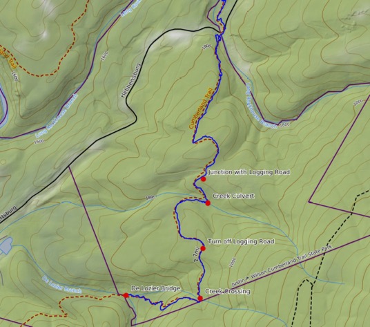
Just past the yellow gate you will see where the connector trail (yellow blazes) starts. Follow this trail for just over a quarter of a mile and then turn left onto the main Cumberland Trail (white blazes.) In 0.5 mile cross Hebbertsburg Road and continue into the woods following the trail 1.25 miles to the De Lozier wooden bridge.
Driving Directions
From Crab orchard: From the I-40 interchange at Crab Orchard, head north, cross the railroad track and turn left for a short distance and turn right on Hebbertsberg Road. Drive 5.6 miles north on Hebbertsberg Road. When you pass the Eden’s Ridge entrance on the right side of Hebbertsberg Road the next dirt road on the left is the trailhead where you will see the yellow gate.
From Fairfield Glade: Head east along Peavine Road towards Hebbertsberg. After 4.5 miles turn right onto Hebbertsberg Road. After about two miles you will pass E. Keyes Road (The street sign is missing.) on the right and about 0.5 miles further on is the trailhead on the right where you will see the yellow gate set back from the road.
Driving Directions
4.3.1 Daddy's Creek Trailhead (Yellow Gate Parking) to De lozier Bridge
- Hiking Distance: 3.6 miles round-trip
- Trail Length: 1.8 miles
- Rating: Moderate
- Trailhead GPS Coordinates: 35.967006 -84.834143
Trail Description
Just past the yellow gate you will see where the connector trail (yellow blazes) starts. Follow this trail for just over a quarter of a mile and then turn left onto the main Cumberland Trail (white blazes.) In 0.5 mile cross Hebbertsburg Road and continue into the woods following the trail 1.25 miles to the De Lozier wooden bridge. At the bridge stop and begin the return journey.
Driving Directions
From Crab orchard: From the I-40 interchange at Crab Orchard, head north, cross the railroad track and turn left for a short distance and turn right on Hebbertsberg Road. Drive 5.6 miles north on Hebbertsberg Road. When you pass the Eden’s Ridge entrance on the right side of Hebbertsberg Road the next dirt road on the left is the trailhead where you will see the yellow gate.
From Fairfield Glade: Head east along Peavine Road towards Hebbertsberg. After 4.5 miles turn right onto Hebbertsberg Road. After about two miles you will pass E. Keyes Road (The street sign is missing.) on the right and about 0.5 miles further on is the trailhead on the right where you will see the yellow gate set back from the road.
4.3.2 Power Lines to De Lozier Bridge
- Hiking Distance: 2.0 miles round trip
- Trail Length: 1.0 miles
- Rating: Moderate
- Trailhead GPS Coordinates: 35.948905 -84.852150
Description
The trail begins at Hebbertsburg Road just North of the TVA power line right of way. Descend gently with the power lines off to your right. Cross a small drainage in about 150 feet. The trail bends to the left. Shortly, there is a spur trail on the left leading down to a nice rock bluff and small rock house. A second spur on the left leads to the same feature a few yards further along. Continue on through older growth mixed forest.There is a nice stone bench on the left.
Switchback to the left and then in a few feet switchback to the right gently descending into older growth hardwood forest. In about 150 feet, cross three wet weather drainages in the next .1 mile. Notice the TVA power lines through the canopy uphill to the right. Cross the second of three drainages as the trail bends right.
Cross the third drainage as the trail descends into the ravine where it bends left and ascends again to near the crest of the ridge.
Begin to descend to De Lozier Branch. Note the young white pines on the left, the hemlock and mountain laurel.
When you reach the bridge at De Lozier Branch, stop and turn around and retrace your steps.
Driving Directions
4.4 Power Lines To Ozone Falls (on Road)
- Distance: 8.0 miles
- Rating: N/A
- Trailhead GPS Coordinates: 35.948905 -84.852150
Driving Directions
Drive south on Hebbersturg Road for 3.3 miles and turn left on to Main Street. After half a mile turn left at the flashing light on to US 70. Follow US 70 for four miles to Ozone Falls. The parking lot is on the left, the trail to falls is on the right.
4.5 Ozone Trailhead to Black Mountain Summit Trailhead
- Hiking Distance: 13.4 miles round trip
- Trail Length: 6.7 miles
- Rating: Strenuous
- Trailhead GPS Coordinates:
Description
Driving Directions
4.6 Black Mountain Summit trailhead to Hwy 68 Trailhead
- Hiking Distance: 6.8 miles round trip
- Trail Length: 3.4 miles
- Rating: Moderate
- Trailhead GPS Coordinates:
Description
Driving Directions
4.6.1 Black Mountain Summit Trailhead to Windlass Cave
- Hiking Distance: 3.8 miles round trip
- Trail Length: 1.9 miles
- Rating: Moderate
- Trailhead GPS Coordinates:
Description
Driving Directions
4.6.2 Hwy 68 Trailhead to Windlass Cave
- Hiking Distance: 3.0 miles round trip
- Trail Length: 1.5 mile
- Rating: Moderate
- Trailhead GPS Coordinates: 35.870433, -84.929764
Description
Note 1: Take care that you take the trail north towards Black Mountain. Do not head south towards the Brady Mountain. That is the wrong direction. Stop and turnaround!
Cross the road and start up the Black Mountain Trail. Hike trail steadily uphill for about one and a half miles to Windlass Cave. The cave iteself is closed to the public to protect the bats in the cave itself from the white-nose disease. Take a well-earned rest before turning around and heading back downhill to the trailhead to complete this 3.0-mile hike.
Driving Directions
Driving from Crossville: Take route 127 south. At the Homestead Tower leave route 127 and follow route 68 towards Grassy Cove and Spring City. After four miles pass Cox Valley Road on the left. Shortly afterwards identify the Brady Mountain trailhead parking on the right, just a shoulder along Route
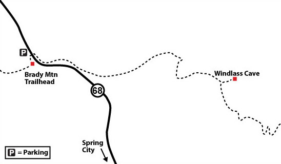
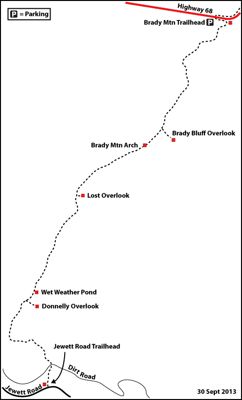
4.7 Hwy 68 to Jewitt Rd (Brady Mt)
- Hiking Distance: 15.6 miles roundtrip
- Trail Length: 7.8 miles
- Rating: Strenuous
- Trailhead GPS Coordinates: 35.870433, -84.929764
Description
Note 1: Take care that you take the trail south. Do not head north towards the Black Mountain. That is the wrong direction. Stop and turnaround!
The Brady Mountain Section includes a beautiful ridge-line hike with a panoramic lookout over Grassy Cove at Brady Bluff Overlook. Much of the trail follows old overgrown double-track roadbeds. It also crosses several such roadbeds that are not to be followed. Pay special attention to the white blazes. The trail follows Brady Ridge on a roadbed and the trail becomes much more obvious to follow.
Driving Directions
Brady Mountain Trailhead on Hwy 68; take TN 68 for 4.6 miles from the Highway 68/127 junction just east of Crossville, Tennessee. The trailhead is a large paved pull-off on the right at the top of the rise above Grassy Cove. Brady Mountain Trailhead serves as the southern terminus for the Black Mountain Section and the northern terminus for the Brady Mountain Section.

4.8 Jewitt Road to HoS Trailhead
- Hiking Distance: 2.0 miles round trip
- Trail Length: 1.0 miles
- Rating: Moderate
- Trailhead GPS Coordinates:
Description
Driving Directions
4.9 Additional Hiking Segments
4.9.1 Peavine Road to Whiteoak Branch Bridge
- Hiking Distance: 2.6 miles round trip
- Trail Length: 1.3 miles
- Rating: Moderate
- Trailhead GPS Coordinates: 36.000824, -84.825522
Trail Description
Note 1: Take care that you take the trail south. Do not head north towards the Devil’s Breakfast Table. That is the wrong direction. Stop and turnaround!
This is a new trail constructed in the summer of 2025. The first half mile is easy with very little change in elevation. The second half mile is a little more challenging with some elevation changes and rock steps.
The final half mile is even more challenging with significant elevation and many large rock steps.
About 1.3 miles from the trail head you will come to a large metal bridge over Whiteoak Branch. Turn around at this bridge and retrace your steps to your vehicle.
Driving Directions
This trailhead is about 3.5 miles from the corner of Peavine Road and Stonehenge Drive (the last stop light) on Peavine Road in Fairfield Glade, heading away from Crossville, towards Hebbertsburg.
The trailhead parking is located on the right hand side of the road. It is not a parking lot, just pull-off at the side of the road. Do not cross the road. The trail entrance is on the same side of the road as the parking area.
4.9.2 E Keyes Road to Daddy's Creek Suspension Bridge
- Hiking Distance: 4.4 miles round trip
- Trail Length: 2.2 miles
- Rating: Moderate
- Trailhead GPS Coordinates: 35.987072, -84.829651
Trail Description
Driving Directions
There is limited parking at the E. Keyes Road trailhead.
4.9.3 Peavine Road to E. Keys Road (By road)
- Hiking Distance: 3.6 miles round trip
- Trail Length: 1.8 miles one way, along the road
- Rating: N/A
- Trailhead GPS Coordinates: 36.000824, -84.825522
Trail Description
This section of the Cumberland Trail is along Peavine Road and Hebbertsburg Road to the E Keyes Road trailhead because the park was unable to obtain permission to build this route on private property.
There is no space to park at the E Keyes Road trailhead.
An alternate route, on the west bank of Daddys Creek is under construction but it will not be complete until a bridge is constructed over Daddys Creek near the Fairfield Glade Overlook Trail. Trail 4.3 Peavine Road to Whiteoak Branch Bridge is part of this alternate route. There is no completion date published for the Daddys Creek bridge.
Driving Directions
This trailhead is about 3.5 miles from the corner of Peavine Road and Stonehenge Drive (the last stop light) on Peavine Road in Fairfield Glade, heading away from Crossville, towards Hebbertsburg.
The trailhead parking is located on the right hand side of the road. It is not a parking lot, just pull-off at the side of the road. Do not cross the road. The trail entrance is on the same side of the road as the parking area.

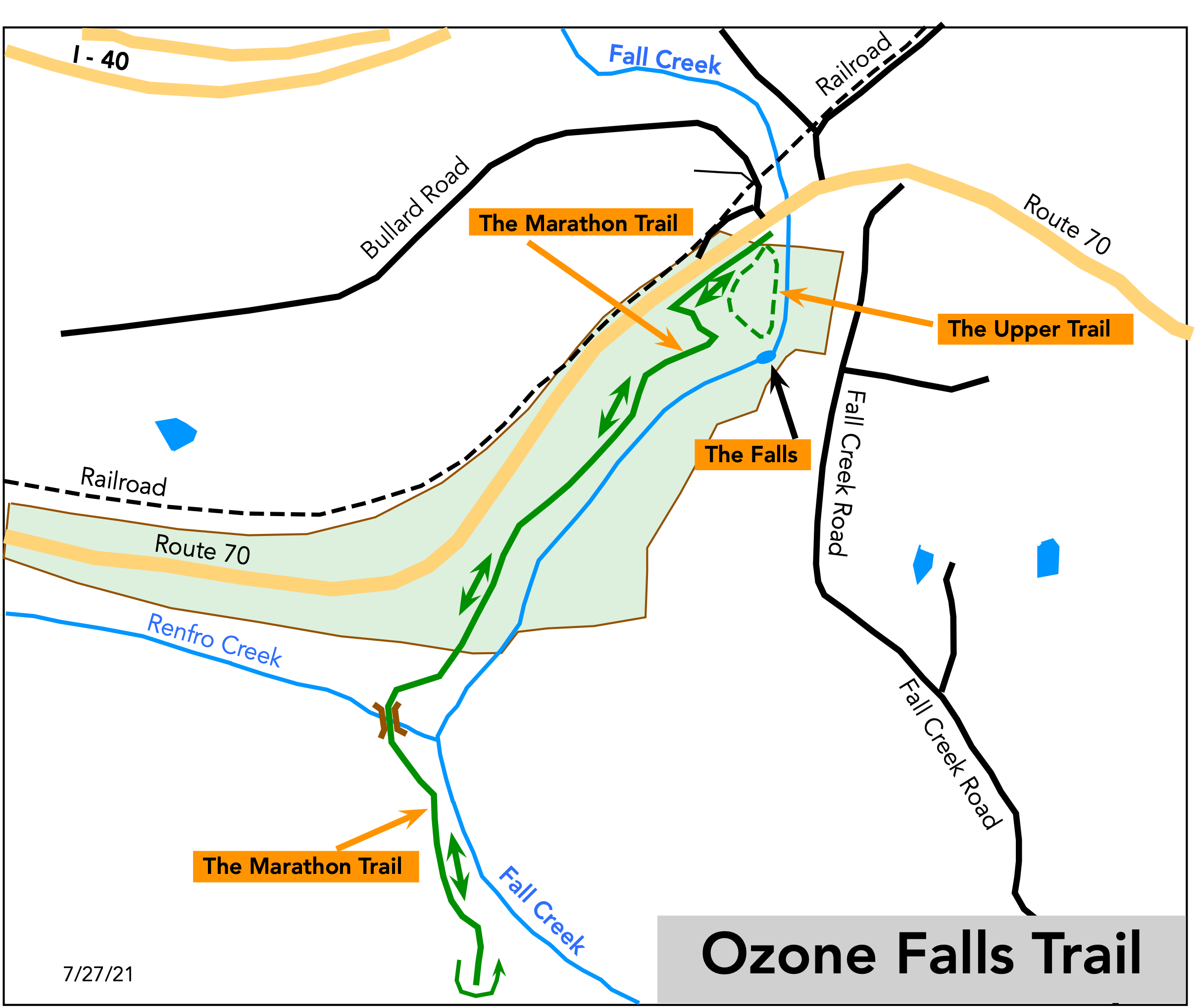
4.9.4 Ozone Falls Trail
- Hiking Distance: 2.0 miles round trip
- Trail Length: 1.0 miles
- Rating: Strenuous
- Trailhead GPS Coordinates: 35.881776, -84.810082
Driving Directions
Address: 173 Fall Creek Rd., Rockwood, TN 37854
From I-40, take Exit 329 for Crab Orchard, then head east on US-70E for 4.5 miles to the Ozone Falls State Natural Area. Park on either side of the road where parking is available, being careful not to block roads or driveways.
Description
The trail parallels Rte 70 for 50 yards before turning left and heading below the falls. Steep rock steps descend to the base of the falls. USE EXTREME CAUTION, ESPECIALLY IF STEPS ARE WET. Follow the trail and at 0.2 miles, follow the sign towards Black Mountain. At 0.5 miles, cross a white bridge. At exactly 1.0 miles, turn around at the giant rock on the left side of the trail and retrace your steps and climb up the rock steps to the road. To visit the top of the falls before you leave, walk 100 yards from the large Ozone Falls State Natural Area sign.


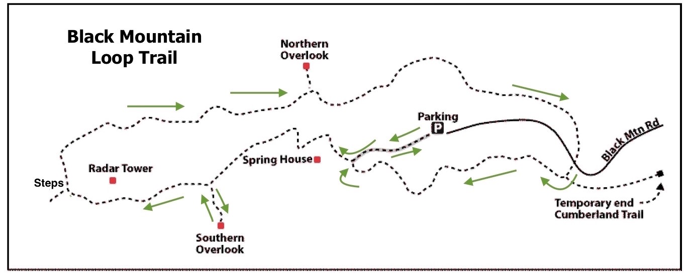
4.9.5 Black Mountain Summit Loop
- Hiking Distance: 2.0 miles loop
- Trail Length: 2.0 miles
- Rating: Easy
- Trailhead GPS Coordinates: 35.868440, -84.887748
Note: Drive carefully on Owl Roost Road as it is a single track road with few passing places.
Description
After parking the car, follow the signs to the Main Trail and the South Overlook. After enjoying the views at the overlook return to the Main Trail and head south along this section of the Cumberland Trail. You can take the staircase down off the summit if you want to admire the rock formations, then back up the stairs and turn left onto the loop trail to the northern overlook (which is overgrown and not very impressive). Continue along the loop trail, crossing over the access road. Note where the main, Cumberland Trail branches off the left but remain on the loop trail and return to the parking lot. The trails in the park pass close to steep drop-offs in many places so children should be supervised.
Driving Directions
Take Bat Town Road south from the Crab Orchard exit from I-140, Exit 329. After about two miles turn left onto Owl Roost Road where it is signed to the Justin P Wilson State Park. Take Owl Roost Road and Black Mountain Road for three miles to the parking lot at the summit of the mountain.
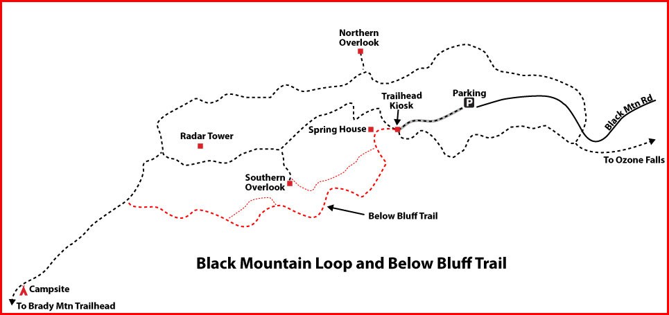
4.9.6 Black Mountain: Below the Bluffs
- Hiking Distance: 1.0 miles round trip
- Trail Length: 0.5 miles
- Rating: Easy
- Trailhead GPS Coordinates: 35.868440, -84.887748
Description
Don Deakins reports that the CT in 2018 officially recognized a casual trail used for years by visitors. Now designated the “Below the Bluffs Trail”. The 2,375′ lower loop connects from the kiosk to the main trail less than 500′ south of Gateway Stairs. Route shown in red on the map. From the Kiosk continue straight to the Spring House, cross the stream, follow the old road. In a short distance there is an old house foundation, turn toward the house. Continue past the house, curving to the right, continue on the old road.
Driving Directions
Take Bat Town Road south from the Crab Orchard exit from I-140, Exit 329. After about two miles turn left onto Owl Roost Road where it is signed to the Justin P Wilson State Park. Take Owl Roost Road and Black Mountain Road for three miles to the parking lot at the summit of the mountain.
4.9.7 Head of Sequatchie: Selby Loop + Devil Step Cave
- Hiking Distance: 1.6 miles
- Trail Length: 1.4 miles
- Rating: Moderate
- Street Address: 270 Glyph Parkway, Pikeville, TN 37367
- Trailhead GPS Coordinates: 35.794242, -85.012695
ABOUT THE HEAD OF SEQUATCHIE
NOTE: The Head of Sequatchie is a state park with restricted opening hours: currently 9:00 am to 4:30 pm daily.
The Head of Sequatchie is an area of the Justin P. Wilson Cumberland Trail State Park admired for its serenity and beauty. Named for the headwaters of the Sequatchie River, the Head of Sequatchie boasts hiking, history, and pristine beauty serving as a snapshot of a time since passed.
Enjoy the birthplace of the Sequatchie River, which rushes forth as the only natural water outlet of the pristine Grassy Cove to the north as a result of the karst topography of the area. The beginning of the Sequatchie Valley, which stretches into Alabama, is an excellent place for picnics, outings, and gatherings of all sorts.
Driving Directions
270 Glyph Parkway, Pikeville, TN 37367.
Take Hwy 127S south out of Crossville. At the Homestead Tower, keep right on Hwy 127S. Continue about 5.7 miles, passing Cumberland Mountain State Park and Basses Creek Bridge.
Turn left onto Brown Rd, a tar and chip road. Follow for 0.8 miles to a T-junction; turn left onto Rhea Rd. Drive for 0.5 miles to a T-junction; turn right onto Old Hwy 28 S. Drive carefully 2.5 miles down this narrow, winding road. Turn left on Glyph Parkway at the Head of Sequatchie sign.
Follow this road to the paved parking area at the bottom of the hill.
Trail Description
By: Stella M. Gonzales-Woodworth
June 21, 2026
The Selby Loop at Head of Sequatchie offers a peaceful journey through one of Tennessee’s most historically and naturally significant landscapes. Beginning at the parking area, hikers cross the entrance footbridge spanning the headwaters of the Sequatchie River. The Head of the Sequatchie is the birthplace of the Sequatchie River, where crystal-clear water emerges from the underground karst spring fed by the extensive Mill Cave System. The footbridge provides visitors with unique opportunity to cross the river at its very source.
Just beyond the bridge, the Head of Sequatchie Ranger Station serves as the park headquarters and visitor center for Justin P. Wilson Cumberland Trail State Park. Operated in partnership with the Cumberland Trail Conservancy, the facility provides information about the area’s natural, historical and recreational resources.
To the right of the entrance stands the interpretive shelter associated with Devilstep Hollow Cave, one of Tennessee’s most significant archaeological and geological treasures. The cave is renowned for its prehistoric Native American artwork and serves as the underground source feeding the Head of Sequatchie Spring.
Devilstep Hollow Cave contains some of the most important cave art in the southeastern United States. Archaeologists have documented petroglyphs, pictographs, and mud glyphs created by Mississippian peoples approximately 1,000-1,100 years ago. Among the images are birds, fish, and the famous “Falcon Warrior” figure, for which the nearby Falcon Warrior Trail is named. Researchers believe the cave held ceremonial and spiritual significance and may have been viewed as an entrance to the underworld in Mississippian cosmology. Much of the artwork is located in the transitional zone where daylight fades into darkness, reinforcing the symbolic passage between worlds. To protect these fragile cultural resources and the sensitive cave environment, public access to the cave is restricted to viewing the site from designated overlooks and interpretive areas.
Geologically, Devilstep Hollow Cave is part of the Mill Cave System, a vast limestone cave network formed through karst processes. The cave serves as a major drainage outlet for Grassy Cove, a remarkable geological basin often described as one of North America’s largest sinkhole formations. Water flowing through the underground cave systems emerges nearby to form the headwaters of the Sequatchie River.
The Selby Loop is a 1.5-mile trail that begins near Devilstep Hollow Cave and gradually climbs through a forested hillside and quiet solitude rich with towering hardwoods, scenic overlooks, and quiet solitude. Known for its serenity and unspoiled beauty, the trail showcases the remarkable headwaters of the Sequatchie River and offers a glimpse into a landscape that has remained largely unchanged for centuries.
Along the route, hikers may connect with the easy-to-moderate Falcon Warrior Trail, a half-mile path that begins at the birthplace of the Sequatchie River. Here, crystal-clear water flows from the cave system as the natural outlet of the Grassy Cove. The trail winds gently through the forest to an overlook above Devilstep Hollow Cave and passes historic Sherrill Cemetery, the resting place of Craven Sherrill, Cumberland County’s first sheriff and descendant of Katherine “Bonnie Kate” Sherrill, wife of Tennessee pioneer and first governor John Sevier.
As you explore these trails, you follow pathways once travelled by Native Americans and Tennessee’s earliest European settlers. During the Mississippian Period, Devilstep Hollow Cave served as an important memorial site, connecting the natural and spiritual worlds. Today, the Selby Loop and Falcon Warrior Trail combine natural wonder, cultural heritage, and quiet woodland beauty to offer an unforgettable journey through the heart of Tennessee’s past.
The Head of Sequatchie also marks the beginning of the Sequatchie Valley, a scenic corridor that extends southwest to Alabama. This beautiful setting provides an ideal location for picnics, outings, photography, wildlife observation, and educational exploration. Open daily from 9:30 a.m. to 4:30 p.m., the Head of Sequatchie is one of Tennessee’s most distinctive natural landmarks and a destination unlike any other.

4.9.8 Peavine Road to FG Overlook Trailhead
- Distance: 8.0 miles
- Rating: Moderate
- Trailhead GPS Coordinates:35.948905 -84.852150
Description
Driving Directions
4.9.9 E. Keyes Road to Yellow Gate Parking
- Hiking Distance: 9.6 miles round-trip
- Trail Length: 4.8 miles
- Rating: Moderate
- Trailhead GPS Coordinates: 35.987689 -84.829718
Note 1: More detailed information can be found on the Daddy’s Creek section of the Cumberland Trail Conference website
Note 2: There is no provison for parking at the E Keyes Road Trailhead so it may be more convenient to start at the Yellow Gate and hike the trail in the reverse direction.
Trail Description
The trail is clearly marked. Look out for the primitive campsite and the overlook. After 4.6 miles turn left on to the connector trail to the Yellow Gate parking lot.
Driving Directions
From East or West, take I40 Exit 329, Crab Orchard. From East, turn right; from West turn left toward the little town of Crab Orchard. Cross US 70 and the railroad track. Turn left on Main Street. In a short distance turn right on Hebbertsburg Road. In 5.2 miles pass the yellow gate parking area on the left. There is a large sign on the left at the trailhead that reads “Cumberland Trail Daddy’s Creek”. Continue another 1.2 miles to East Keyes Road on left. See a large TDEC sign for Keyes-Harrison WMA. Turn left onto East Keyes Road. Shortly on the left is an opening into the power line right of way. You can park here and walk East Keyes Road for about .3 mile to the trailhead on the left or continue about .3 mile to the trailhead on the left and park on the either side of the road but well off the road.
