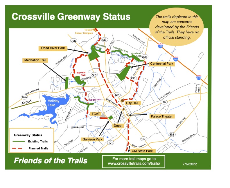
Hiking the Crossville Green way trails
1. The Crossville Greenway
Trails are used more when they are constructed near population centers and that is why the Friends of the Trails is concentrating its efforts on building the Greenway within the Crossville City limits.
While most people are familiar with city or county parks, a new type of park, called Greenways, have been developed across the nation over the past several decades.
Greenways are corridors of land recognized for their ability to connect people and places together. These ribbons of open space are located within linear corridors that are either natural, such as rivers and streams, or manmade, such as abandoned railroad beds and utility corridors.
Greenways, as vegetated buffers protect natural habitats, improve water quality and reduce the impacts of flooding in floodplain areas. Most greenways contain trails, which enhance existing recreational opportunities, provide routes for alternative transportation, and improve the overall quality of life in an area.
Greenway trails can be paved or unpaved, and can be designed to accommodate a variety of trail users, including bicyclists, walkers, hikers, joggers, skaters, horseback riders, and those confined to wheelchairs.
Trails are used more when they are constructed near population centers and that is why the Friends of the Trails is concentrating its efforts on building the Greenway within the Crossville City limits.
The number of miles of natural surfaced trails are increasing in Crossville due to the efforts of the Friends of the Trails, a non-profit volunteer group working in partnership with the city.
Hikes on the Crossville Greenway
- Centennial Park Trail, Paved, 1.5 miles, Easy
- Wood Lawn Loop, 1.2 miles, Easy
- Little Obed River Trail, 0.7 miles, Easy
- Woodlawn Loop & Little Obed Trail, 2.6 miles, Easy
- TCAT Trail, 0.5 miles, Easy
- Obed River Park Trail, Paved, 1.5 miles, Easy
- Maryetta Trail, 1.7 miles, Moderate
- Meditation Trail, 1.0 miles, Easy
- Habitat Trail, 2.1 miles, Easy
- Airport North Trail, 2.3 miles, Moderate
- Airport South Trail, 2.5 miles, Easy
- Charleston Place Trail, 2.1 miles, Easy (CLOSED)
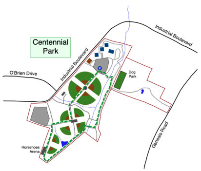
1.1 Centennial Park Trail
- Hiking Distance: 1.2 miles
- Trail Length: 1.2 miles
- Rating: Easy
- Trailhead GPS Coordinates: 35.967940, -85.026750
Driving Directions
From I-40 take exit 320 for Genesis Road towards Crossville. Turn left on Genesis Road and drive 1.1 miles. Turn right on Industrial Road and drive 0.9 miles. Turn left into the complex and park towards the back right-hand side of the park near the dog park.
Trail Description by Stella M. Gonzales-Woodworth
June 5, 2026
Located in the heart of Crossville, Tennessee, the Centennial Park Paved Trail offers a pleasant and family-friendly outdoor experience for walkers, joggers, and nature enthusiasts. This easy 1.2-mile paved trail winds through one of the city’s most popular recreational areas, providing a relaxing journey surrounded by sports facilities, open green space, and natural scenery.
The Centennial Park Paved Trail entry point provides convenient access to pleasant walking route through one of the area’s most popular parks. Visitors should be aware that there are currently no signs marking the trail route, which can make navigation somewhat challenging for first-time users. It is recommended to review the park map before beginning your walk to better understand the trail layout and enjoy a relaxing and enjoyable stroll through the park’s surroundings.
It’s nice to start the walk at the charming plaza adorned with three flags, where visitors are welcome into a well-maintained park that combines recreation, nature, and community spirit. The trail meanders between impressive softball and baseball fields, passes the horseshoe building, and loops around the park’s spacious grounds. Along the way, hikers can enjoy views of friendly games in progress, watch dogs playing in the nearby dog parks, and admire the peaceful environment.
One of the trail’s hidden gems is its scenic stretch along Little Obed River, where mature trees, native grasses, and open spaces create a refreshing natural setting. Although much of the trail is open to the sunshine, making morning walks especially enjoyable, the beautiful landscape and gentle terrain make every season a great time to visit.
The Centennial Park Paved Trail is designed to be accessible and welcoming to everyone. The mostly paved surface is suitable for Americans with Disabilities, children, families with strollers, young adults, and senior citizens. It is also an excellent route for casual exercise, jogging and leisurely walks. Visitors should note that dogs are welcome in designated areas and dog parks but are not permitted near the ball fields.
Rich in local history, the park began as Crossville Recreation Park in 1992 and has expanded over the years into a premier community destination. Future connections to the Greenway, Woodlawn Trail, and Little Obed River corridor will make this trail even more appealing.
Whether you’re seeking exercise, relaxation, nature, or quality family time, the Centennial Park Paved Trail offers a beautiful and inviting outdoor experience for visitors of all ages.
1.2 Woodlawn Loop Trail
- Hiking Distance: 1.2 miles
- Trail Length: 1.2 miles
- Rating: Easy
- Trailhead GPS Coordinates: 35.974659, -85.025064
Trail Closed
This trail closed on March 16 and will reopen on July 1st 2026
Description
This is a delightful figure-of-eight woodland trail that was constructed in 2017. Part of the trail is along the Little Obed River but you only get glimpses of the river as you pass close by.
Driving Directions
Driving Directions Address: Wyatt Ct., Crossville, TN 38555 From I-40, take exit 320, for Genesis Rd. toward Crossville. Turn left on Genesis Rd and drive 0.7 miles. Turn right on Woodlawn Rd for 0.5 miles. Turn left on Wyatt Ct and drive 0.2 miles until it becomes a gravel road. Pass through the gateway and pull into the trailhead parking area.
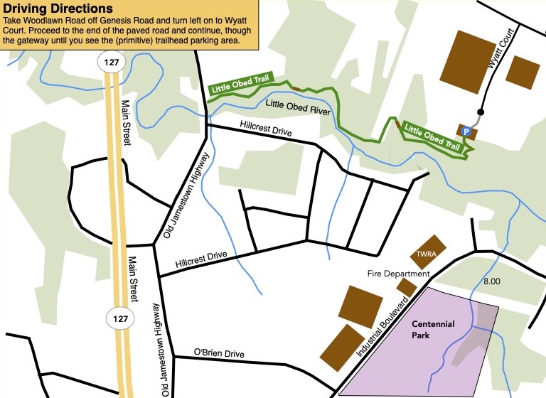
1.3 Little Obed River Trail
- Hiking Distance: 1.4 miles round trip hike
- Trail Length: 0.7 mile trails
- Rating: Easy
- Trailhead GPS Coordinates: 35.974659, -85.025064
Trail Closed
This trail closed on March 16 and will reopen on July 1st 2026.
Description
To hike the Little Obed Trail, constructed in 2020, you will start off by taking the Woodlawn loop trail from the trail-head parking lot. Turn right at the first junction in the woods. A short distance later turn right again to get on to the Little Obed Trail. It is a nice easy trail that gets closer to the river in places. The trail ends at Old Jamestown Highway. Eventually we hope to continue the trail on the other side of the road but for now we recommend that you turn around when you see the road and return to the trail-head where you started.
Driving Directions
Driving Directions Address: Wyatt Ct., Crossville, TN 38555 From I-40, take exit 320, for Genesis Rd. toward Crossville. Turn left on Genesis Rd and drive 0.7 miles. Turn right on Woodlawn Rd for 0.5 miles. Turn left on Wyatt Ct and drive 0.2 miles until it becomes a gravel road. Pass through the gateway and pull into the trailhead parking area.
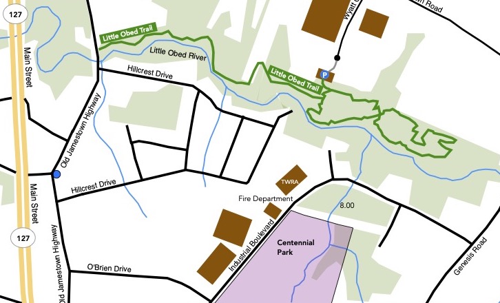
1.4 Woodlawn Loop & Little Obed Trail
- Hiking Distance: 2.6 miles
- Trail Length: 1.9 miles
- Rating: Easy
- Trailhead GPS Coordinates: 35.974659, -85.025064
Trail Closed
These trails closed on March 16 and will reopen on July 1st 2026.
Description
This hike combines the two trails to make a longer hike. The Woodlawn Loop is a delightful figure-of-eight woodland trail that was constructed in 2017. Part of the trail is along the Little Obed River but you only get glimpses of the river as you pass close by.
To hike the Little Obed Trail, constructed in 2020, you will start off by taking the Woodlawn loop trail from the trail-head parking lot. Turn right at the first junction in the woods. A short distance later turn right again to get on to the Little Obed Trail. It is a nice easy trail that gets closer to the river in places. The trail ends at Old Jamestown Highway. Eventually we hope to continue the trail on the other side of the road but for now we recommend that you turn around when you see the road and return to the trail-head where you started.
Driving Directions
Driving Directions Address: Wyatt Ct., Crossville, TN 38555 From I-40, take exit 320, for Genesis Rd. toward Crossville. Turn left on Genesis Rd and drive 0.7 miles. Turn right on Woodlawn Rd for 0.5 miles. Turn left on Wyatt Ct and drive 0.2 miles until it becomes a gravel road. Pass through the gateway and pull into the trailhead parking area.
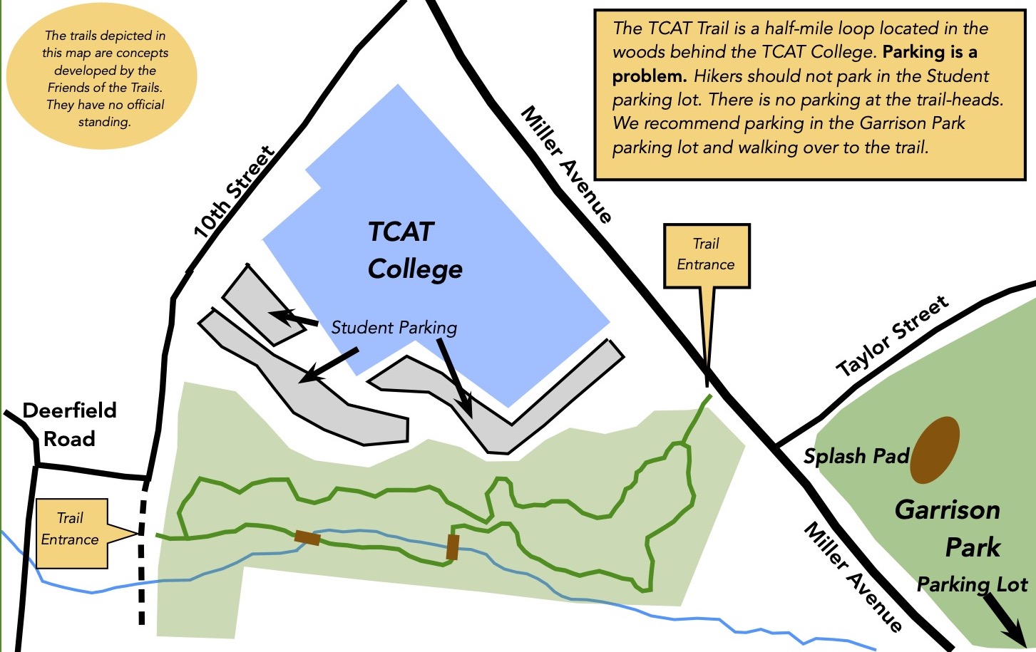
1.5 TCAT Trail
- Hiking Distance: 0.5 miles
- Trail Length: 0.5 miles
- Rating: Easy
- Trailhead GPS Coordinates: 35.945185, -85.035752
Trail Closed
This trail is temporarily closed in the Spring of 2026 due to the presence of a homeless camp and large amounts of trash strewn around the property. It will reopen when the property has been cleaned up.
Description
This short 0.5 mile trail has been constructed mainly for the use of the college students and staff but it is open to the public. It was opened in January 2023. It is an easy trail that offers a calm walk in the woods.
Driving Directions
Parking for this short trail is in the Garrison Park parking lot at the corner of Miller Avenue and 4th Street in downtown Crossville. Please do not park in the college student parking lots as spaces are very limited.
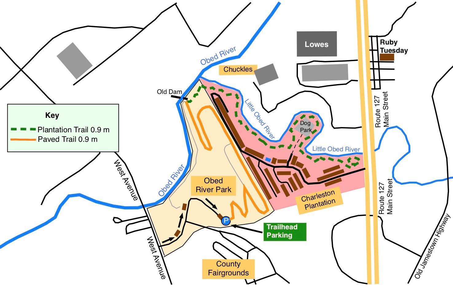
1.6 Obed River Park Trail
- Hiking Distance: 1.5 miles
- Trail Length: 1.5 miles
- Rating: Easy
- Trailhead GPS Coordinates: 35.973617, -85.044277
Driving Directions
From Peavine Road go east on First Street toward Crossville. After 2.7 miles turn right on West Avenue (Hwy. 70 E). After 2.3 miles turn right on Obed River Park Drive. Proceed 0.2 miles to the gravel parking lot.
Description
By: Stella M. Gonzales-Woodworth
June 5, 2026
Situated in the midst of Crossville, Tennessee, the Obed River Park Paved Trail and Arboretum offers a peaceful and scenic outdoor experience for visitors of all ages. Established by the City of Crossville in 1982, this beautiful park features a 2.1 miles of paved walking trails that wind through an idyllic natural setting while providing modern amenities and easy accessibility.
The adventure begins with one of the trail’s most captivating sights – the beautiful Obed River. Flowing gently through the park, the river creates a serene atmosphere and provides stunning river views that immediately welcome hikers, walkers, and nature lovers. As you continue along the trail, approximately half of the route is shaded by mature trees, making it a comfortable destination throughout much of the year.
History and nature blend together along the trail. Visitors can view the remains of the failed G. E. Harrison and J. Ridley Mitchell Dam, learn about the former Tennessee Central Railroad Trestle and Corridor, and discover a variety of native trees identified throughout the arboretum. Numerous bluebird houses and outdoor fitness stations add interests and enjoyment along the way.
The park is designed to be welcoming for everyone. The smooth, paved trail is ideal for walking, jogging, and biking, making it a favorite destination for outdoor enthusiasts seeking a safe and enjoyable place to exercise. The trail is also friendly to American with Disabilities, families with strollers, children, young adults, and senior citizens. Leashed pets are welcome as well, making it an ideal destination for the entire family.
Additional amenities include a playground for children, picnic tables for relaxing outdoor meals, and a charming free book exchange located near the entrance. Visitors are encouraged to take a book home and are welcome to donate books for others to enjoy.
Whether you are seeking a leisurely stroll, a family outing, exercise, or a chance to connect with nature and local history, Obed River Park Paved Trail and Arboretum is one of Crossville’s most inviting and enjoyable outdoor destinations.
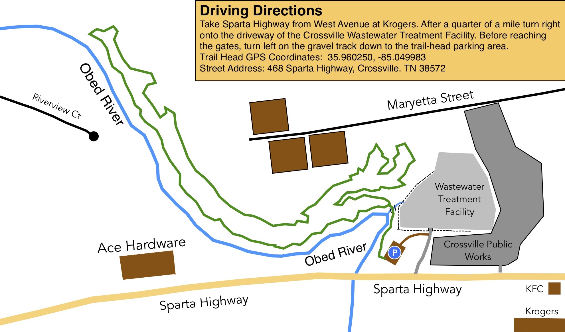
1.7 Maryetta Trail
- Hiking Distance: 1.7 miles
- Trail Length: 1.6 miles
- Rating: Easy
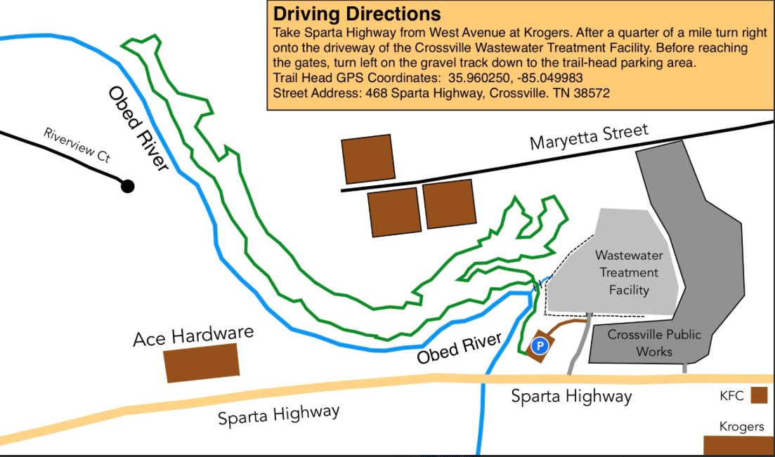
- Trailhead GPS Coordinates:35.960250, -85.049983
Driving Directions
Description
By: Stella M. Gonzales-Woodworth
June 16, 2026
Discover the peaceful beauty of Maryetta Trail, a hidden gem nestled at Crossville, Tennessee. This easy-to-moderate 1.7-mile forest lollipop loop offers a relaxing escape into nature, just minutes from town. Whether you’re looking for a quiet stroll, a scenic hike, or a chance to reconnect with the outdoors, Maryetta Trail provides the perfect setting.
As you begin your adventure, you’ll cross a charming wooden bridge near the trailhead and enter a tranquil woodland landscape. At the loop, hikers can choose their direction: turn left to enjoy peaceful stretches alongside the Obed River, where the soothing sounds of flowing water enhance the experience, or head right to wander through gently rolling hills beneath a refreshing canopy of mature trees.
The trail is rich with natural beauty throughout the seasons. Native plants and colorful wildflowers line the path, while butterflies flutter among the blooms. Keep an eye out for fascinating fungi, especially during wetter months. Wildlife enthusiasts will appreciate frequent sightings of birds, gray squirrels, chipmunks, rabbits, and even deer quietly moving through the forest.
Along the route, hikers will encounter a few short stony and rocky sections that add character and variety to the walk. The trail also features a handful of steeper inclines, but they are brief, well-spaced, and manageable for most visitors. These gentle challenges are balanced by long stretches of peaceful forest scenery, making the overall hike enjoyable for casual hikers, families, nature lovers alike.
Convenient amenities make visiting easy. A free parking area is available at the trailhead near the water treatment facility. From the parking lot, turn right to find a welcoming bench marked “Friends of the Trails” and the wooden bridge that leads directly onto the trail.
With its serene atmosphere, beautiful river views, abundant wildlife, and close proximity to Crossville, Maryetta Trail is a wonderful destination for those looking to slow down, breathe in the fresh forest air, and experience the natural charm of the Cumberland Plateau.
1.8 Meditation Trail
- Hiking Distance: 1.0 miles
- Trail Length: 1.0 miles
- Rating: Easy
- Street Address: 1038 Sparta Hwy, Crossville, TN
- Trailhead GPS Coordinates: 35.959534, -85.060152
Note: Please do not hike this trail on a Sunday morning as the parking lot will be full with the congregation’s cars.
Driving Directions
Head out of Crossville along Sparta Highway, Route 70. After three quarters of a mile pass Ace Hardware on the right. Approximately a quarter of a mile after Ace turn right into the parking lot of the St Raphael Episcopal Church. Park behind the church close to the trailhead.
Description
By: Stella M. Gonzales-Woodworth
June 14, 2026
Escape into a peaceful oasis right in the heart of Crossville at the Meditation Trail located on the grounds of St. Raphael Church. Though only about one mile in length, this charming nature trail offers a relaxing and enjoyable outdoor experience for visitors of all ages.
As you stroll beneath a canopy of mature trees and fragrant pines, you’ll discover a serene setting perfect for reflection, quiet walks, and connecting with nature. Along the trail, a gentle stream winds through the landscape, inviting visitors to cross using stepping stones that add a touch of adventure and fun. A small pond provides a tranquil spot to pause, listen to nature, and enjoy the peaceful surroundings.
Families will especially appreciate the colorful, hand-painted benches scattered along the trail. These cheerful resting spots encourage children to observe, explore, and develop an appreciation for the natural world around them.
One of the trail’s most intriguing features is a unique dome-shaped structure nestled among the trees. Its mysterious appearance sparks curiosity and imagination, inspiring children and adults alike to wonder about its purpose and create their own stories about what it might be.
Visitors can begin their journey through either of two entrances: one with two old gates, the other is just a simple opening and choose to hike the trail clockwise or counterclockwise, creating a different experience each time they visit.
The Meditation Trail offers a wonderful opportunity to enjoy nature without leaving the city. Whether you’re seeking a quiet place for contemplation, a gentle walk, family-friendly exploration, birdwatching, photography, or simply a break from daily routines, this hidden gem provides a refreshing retreat for all.
St. Raphael Church hosts well-attended Sunday services, and the parking lot is typically filled with congregants’ vehicles. To ensure a pleasant experience for both visitors and church members, hiking the trail on Sundays is not recommended.
Come discover the beauty, tranquility, and simple pleasantries of the Meditation Trail at St. Raphael Church – a peaceful natural sanctuary waiting to be explored.

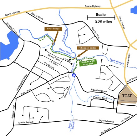
1.9 Habitat Trail
- Hiking Distance: 2.1 miles
- Trail Length: 1.05 miles
- Rating: Easy
- Trailhead GPS Coordinates: 35.949616, -85.048862
Trail Closed
This trail was closed in September 2025 due to the construction of a new subdivision. The closure should be temporary until the layout of the subdivision is complete and the trail can be rerouted. The trail is expected to reopen by the end of 2026
Description
This trail opened in July 2022. The trail-head parking is on Deerfield Road. The trail starts across the road from the parking lot. This is an easy lollypop trail along the Obed River.
Head into the woods from the parking lot. Pass the start of the Town Branch Spur on the right. Keep going crossing the creek itself using stepping stones. Look for the large Hilltoppers Bridge on the left. Cross the bridge over Spiers Branch Creek and follow the trail for about half a mile along the Obed River. At the end of the trail is a short loop which you navigate before returning the way you came. The main trail is 0.7 miles long.
On the way back after crossing the Hilltoppers Bridge and stepping over the Town Branch creek, take the trail on the left and check out the Town Branch Spur. It is an additional 0.2 mile, each way in and out, spur trail We recommend that you take the time to check out this extra section of trail. The in-out distance if you do the main trail and the Town Branch spur, 2.1 miles.
Driving Directions
Take Miller Avenue to the stop light at the TCAT college. Take 10th street alongside the college. Follow the road to the stop sign on Deerfield Road. Turn right and the trailhead parking lot will be on your left.
1.10 Airport North Trail
- Hiking Distance: North Trail 2.3 miles
- Trail Length: North Trail 2.1 miles
- Rating: Moderate
- Trailhead GPS Coordinates: 35.946734, -85.093314
Description
NOTE: The Airport Trail parking lot is used as the trail-head for both the North and South Trails.
Driving Directions:
From Crossville, take Sparta Highway from the Kroger store. Head west for three miles, past the airport termial building and runway. At the end of the runway turn left, just before the recycling center and almost immediately turn left again on to Earl Jones Road. After about a quarter of a mile you will see the trailhead parking lot on the left.
Description
By: Stella M. Gonzales-Woodworth
May 28, 2026
Tucked away in the beautiful hills of Crossville, Tennessee, the North Airport Trail offers a refreshing escape into nature, where peace, movement, and scenic beauty come together. This easy/moderate trail winds through quiet woodlands, open natural areas, and unique terrain that gives hikers a little bit of everything to enjoy. Along the way, visitors and hikers can catch glimpses of planes taking off and landing nearby, creating a one-of-a-kind hiking experience that blends nature with the excitement of the open sky.
Whether you are looking for a relaxing morning walk, a heart-healthy outdoor workout, or simply a chance to clear your mind, the North Airport Trail is the perfect place to reconnect with nature and yourself. The fresh mountain air, shaded paths, and changing scenery make every step feel rewarding. Hiking this trail is not only good for physical fitness, but also helps reduce stress, improve mood and restore mental wellness.
The trail is also a wonderful place to bring your dog for healthy outdoor exercise and fresh air. Many hikers enjoy walking their dogs along the peaceful paths, making it a fun and active experience for both pets and their owners.
The North Airport Trail invites hikers of all skill levels to slow down, breathe deeply and enjoy the natural beauty of Tennessee’s Cumberland Plateau. It is more than just a trail – it is an opportunity to refresh your body, recharge your mind and experience the simple joy of being outdoors.
During the fall season, North Airport Trail transforms into a breathtaking landscape painted with rich shades of gold, crimson and burnt orange. The crisp mountain air, gentle rustling of fallen leaves, and peaceful forest atmosphere create the perfect escape for hikers seeking both adventure and relaxation. Every step along the trail reveals stunning panoramic views, vibrant foliage, and quiet moments surrounded by nature’s beauty.
The trail becomes especially magical in the early morning and late afternoon when sunlight filters through the colorful trees, creating a warm and unforgettable landscape. Wildlife is often more active during autumn, giving visitors the chance to experience nature at its liveliest. Whether you are an experienced hiker, a photographer, or someone simply looking for a peaceful outdoor walk, North Airport Trail in the fall offers a refreshing and memorable experience that captures the true beauty of the season.
In winter, North Airport Trail offers a completely different but equally captivating experience. The trail becomes calm, quiet, and beautifully serene as frosty mornings and occasional light snowfall transforms the surrounding landscape. Bare trees, patches of frost, gently flowing streams, and crisp air create a peaceful environment that feels refreshing and tranquil.
Hiking the trail during winter allows visitors to enjoy scenic woodland views and the subtle beauty of the season while experiencing the stillness of nature away from busy crowds. On rare snowy days, a light dusting of snow adds an extra touch of charm, though it typically does not remain for long. The cool air and quiet atmosphere provide a refreshing sense of escape and adventure.
For hikers who appreciate winter scenery, photography, or simply the beauty of a peaceful trail, North Airport Trail delivers a memorable seasonal experience filled with natural wonder and peaceful solitude
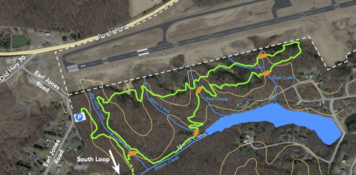
1.11 Airport South Trail
- Hiking Distance: South Trail 2.5 miles
- Trail Length: South Trail 2.0 miles
- Rating: Moderate
- Trailhead GPS Coordinates: 35.946734, -85.093314
By: Stella M. Gonzales-Woodworth
May 28, 2026
Located near the North Airport Trail in beautiful Crossville, Tennessee, the South Airport Trail was
Crossville’s newest trail, having been completed shortly before the 2024 marathon. The trailhead is located at the parking lot on Earl Jones Road, which now serves both the North and South Airport Trails. From the parking lot, follow the trail for approximately one-quarter mile to the junction where the North Airport Trail branches off to the left. The South Airport Trail features a lollipop-shaped layout, consisting of a 0.4-mile stem that connects to a 1.7 mile loop.
Although there are no major features on this trail, it offers hikers a peaceful experience surrounded by the natural beauty of Cumberland Plateau. This scenic trail provides a relaxing setting filled with wooded paths, gentle elevation changes, and quiet moments where visitors and hikers can enjoy the sights and sounds of nature away from the stress of everyday life.
The South Airport Trail is an excellent destination for walking, hiking, jogging and open air fitness. Whether you are seeking a refreshing workout, a family-friendly adventure, or simply a peaceful place to unwind, it is a hidden gem in Crossville that offers the perfect balance of recreation, wellness and alfresco beauty.
Dog lovers will also appreciate the trail as a wonderful place to bring pets for daily walking exercise and outdoor enjoyment. The spacious natural setting gives both owners and dogs an opportunity to stay active while enjoying quality time together in a safe and scenic environment.
South Airport Trail becomes exceptionally beautiful during the fall season, offering hikers a colorful and scenic outdoorsy experience surrounded by nature’s changing landscape. The trail is lined up with vibrant autumn foliage, where shades of red, orange and yellow stretch across the hillsides and forests, creating picture-perfect views around every corner.
The cool, refreshing air and peaceful atmosphere make fall one of the best times to explore the trail. Hikers can enjoy the soothing sounds of leaves crunching beneath their feet while taking in sweeping views of the surrounding valleys and woodlands. The trail’s natural beauty, combined with the comfortable temperatures and stunning seasonal colors, creates an environment for photographers, families, and outdoor enthusiasts alike. South Airport Trail in autumn offers a memorable hiking experience filled with relaxation, adventure, and breathtaking scenery.
During winter, South Airport Trail offers a peaceful retreat for hikers seeking the quiet beauty of the season. While heavy snowfall is uncommon in Crossville, occasional light snow and frosty mornings can add a special charm to the landscape. Bare hardwoods, evergreen pines, and crisp, cool air create a serene setting that highlights the natural character of the trail.
The winter months provide excellent opportunities to enjoy unobstructed views through the leafless forest, observe seasonal wildlife activity, and experience the tranquility that accompanies the colder season. On days when snow dusts the ground or frost sparkles in the morning sunlight, the trail takes on an especially picturesque appearance. Whether visitors are looking for a refreshing winter hike, a photography outing, or simply a peaceful escape into nature, the South Airport Trail showcases the subtle beauty and quiet appeal of winter on the Cumberland Plateau.
Driving Directions:
From Crossville, take Sparta Highway from the Kroger store. Head west for three miles, past the airport termial building and runway. At the end of the runway turn left, just before the recycling center and almost immediately turn left again on to Earl Jones Road. After about a quarter of a mile you will see the trailhead parking lot on the left.
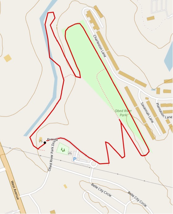
1.12 Charleston Place Trail
- Hiking Distance: 3.6 miles
- Trail Length: 0.9 miles
- Rating: Easy
- Trailhead GPS Coordinates: 35.973718, -85.044335
Trail Closed
Description
This trail is closed due to excessive overgrown vegetation along the trail. Discussions are taking place to determine what steps can be taken to pave this trail.
==================
The trailhead is in the second parking lot. The route passes along the paved trail (0.9 miles) towards the old dam on the Obed River, turn left onto the dirt Charleston (formerly Plantation) trail (0.9 miles). Enjoy this trail as it winds along the Little Obed River. At the end of the trail retrace your steps back to paved trail and return along the Obed River to the trail-head.
Driving Directions
Head out of Crossville on Route 70N, West Avenue, after 1.5 miles from the Kroger’s Plaza, turn right into the Obed River Park. Take the third turn on the left into the parking lot which is the trail-head. (0.9 miles)