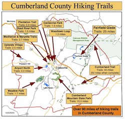
Hiking in Cumberland County West
5. Trails of cumberland County West
As you hike these trails you will enjoy a wide variety of terrain and geographical features. We hope these trails take you places that you would not normally go and that you have positive experiences along the way. We hope you enjoy hiking these trails but please stay on the trail when hiking and respect private property in residential communities. Carry plenty of water at all times, use bug-spray and watch your step – it is easy to twist an ankle on rocks and tree roots. Pets are permitted on (nearly) all trails but please pick up after your dog if it fouls the trail-bed.
Table of Contents
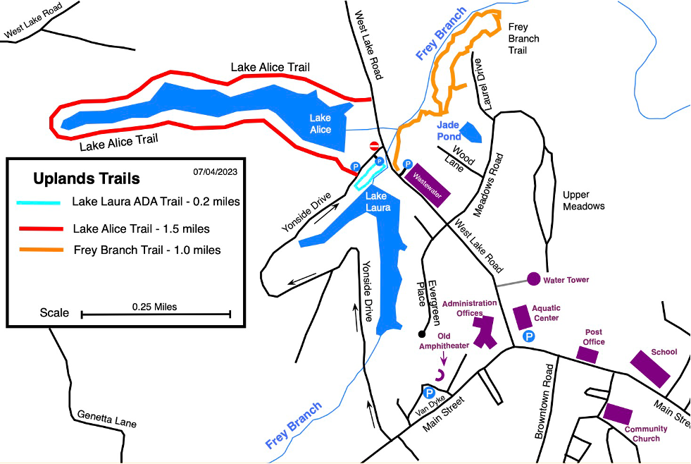
Uplands Village
5.1 Lake Alice Trail, 1.5 miles, Easy
5.2 Frey Branch Trail, 1.0 mile, Moderate
5.3 Adshead Trail
5.4 Lake Laura ADA Trail (paved)
Meadow Creek Park
5.5 Gateway Trail, 3.0 miles, Moderate
Static PDF Map
5.1 Lake Alice Trail
- Hiking Distance: 1.5 miles
- Trail Length: 1.5 miles
- Rating: Easy
- Trailhead GPS Coordinates: 35.982341, -85.204573
Description
In the Uplands Village Trails there are three trails with their trail-heads within walking distance of each other.
The Lake Alice Trail has been on the marathon a few times and is a pleasant, easy, hike around the lake. The official trail includes a short section of West Lake Road but it can be bypassed in dry weather if the spillway can be safely crossed and you can return along the dam to the trailhead
Driving Directions
The Lake Alice Trail is in Uplands Village, Pleasant Hill. Take the Sparta highway from Crossville for 10 miles then, shortly after passing a gas station on the left, take the right turn on East Main Street into the village. Pass the Elementary School and a short distance later turn right on to West Lake Road. After about half a mile pull over to the left onto Yonside Drive and immediately left again into the gravel trailhead parking from where you can access all three trails.
NOTE: Yonside is a one way street. However it is acceptable to enter Yonside the wrong way for the very short distance to the parking lot
5.2 Frey Branch Trail
- Hiking Distance: 1.0 miles
- Trail Length 1.0 miles
- Rating: Moderate
- Trailhead GPS Coordinates: 35.982341, -85.204573
Description
The Frey Branch Trail is a one-mile trail through some steep and rocky terrain in the woods. It has a delightful “rainforest” feel about it.
Driving Directions
The Lake Alice Trail is in Uplands Village, Pleasant Hill. Take the Sparta highway from Crossville for 10 miles then, shortly after passing a gas station on the left, take the right turn on East Main Street into the village. Pass the Elementary School and a short distance later turn right on to West Lake Road. After about half a mile pull over to the left onto Yonside Drive and immediately left again into the gravel trailhead parking from where you can access all three trails.
NOTE: Yonside is a one way street. However it is acceptable to enter Yonside the wrong way for the very short distance to the parking lot.
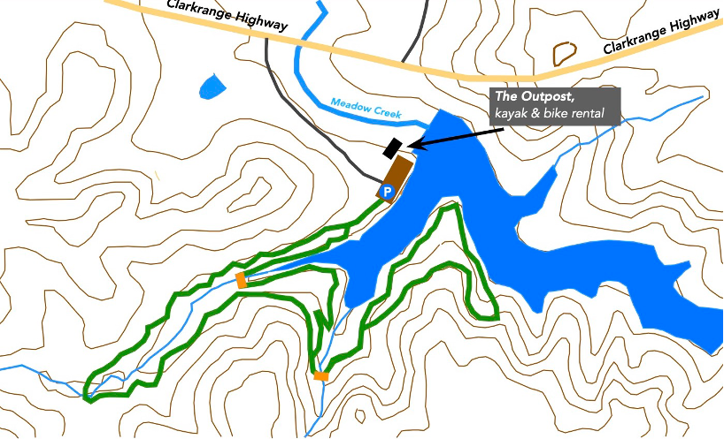
5.5 Gateway Trail at Meadow Creek Park
- Hiking Distance: 3.0 miles
- Trail Length 3.0 miles
- Rating: Moderate
- Trailhead GPS Coordinates: 36.115286, -85.187851
Description
Meadow Creek Park is a multi-use recreational park that is being developed, by the town of Monterey for mountain biking, hiking, fishing, kayaking, etc. There are many trails in the park but they are primarily biking trails but hikers are welcomed. A trail all around the lake is under construction.
NOTE: Take care and watch out for mountain bike riders while on the trail…especially if you have a dog on a leash.
The Gateway Trail is one of the trails that is a relatively easy hike with a short section around halfway that is rather steep. Navigate carefully as there are many unsigned junctions along the trail.
Driving Direction
From Crossville, take Highway 70 North to Monterey. In Monterey turn right on to South Holly Street for four or five blocks before turning right on to East Commercial Street (which is Monterey’s “Main St.” where you can find a few stores and restaurants).Stay on E Commercial St, which becomes Clarkrange Highway, for five miles. You will see the entrance to Meadow Creek Park on the right. Go to the end of the gravel road, about a third of a mile, to the trailhead parking lot that is shared with fishermen and kayakers.