Hiking at Meadow Park
6. Trails of Meadow Park
As you hike these trails you will enjoy a wide variety of terrain and geographical features. We hope these trails take you places that you would not normally go and that you have positive experiences along the way. We hope you enjoy hiking these trails but please stay on the trail when hiking and respect private property in residential communities. Carry plenty of water at all times, use bug-spray and watch your step – it is easy to twist an ankle on rocks and tree roots. Pets are permitted on (nearly) all trails but please pick up after your dog if it fouls the trail-bed.
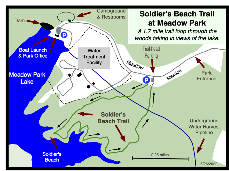
6.1 Soldier's Beach Trail
- Hiking Distance: 1.7 miles
- Trail Length: 1.7 miles
- Rating: Easy
- Trailhead GPS Coordinates: 35.899123, -85.088388
Note: This is called Soldier’s Beach Trail because, during World War 2, German Prisoners of War from a camp in Crossville were used to build a recreational facility here for US Soldier’s families. You can learn more about the POW camp Here
Driving Directions
To get to Meadow Park take Lantana Road, Highway 101, south out of Crossville. After about 3.5 miles, go straight through the lights where Highway 282 turns off for Lake Tansi. The road narrows from four lanes down to two lanes. After another mile turn right on to City Lake Road. There is a large Meadow Park sign on the corner. The trail-head parking is about half a mile on the left but you might want to follow City Lake Road to where it dead-ends at the park marina and office. Enjoy the views across the lake, and maybe use the restrooms at the campsite. Feel free to stop in the office and say “Hi” to the park manager, then drive back up the entrance road 0.6 miles to the trail-head parking lot which will now be on the right hand side of the road.
Description
By: Stella M. Gonzales-Woodworth
May 28, 2026
The Soldier’s Beach Trail in Crossville, Tennessee, offer visitors and hikers a peaceful lakeside escape where natural beauty, relaxation and outdoor recreation come together. Surrounded by scenic woodland views and the calming presence of the water, this trail creates the perfect setting for hikers, walkers, and nature lovers looking to enjoy the outdoors at a slower, more refreshing pace.
As the trail winds through the area, visitors and hikers can experience beautiful shoreline scenery, gentle breezes and quiet moments that make it easy to relax and recharge. Whether you are taking a morning walk, enjoying an afternoon hike, or simply spending time in nature, the Soldier’s Beach Trail provides an excellent opportunity to improve physical fitness while supports mental wellness and reducing everyday stress.
The trail is also a wonderful place for families and dog owners to enjoy healthy outdoor activity together. Many visitors and hikers bring their dogs along for exercise, fresh air, and the enjoyment of exploring the peaceful natural surrounding side by side.
With its inviting atmosphere and scenic lakeside charm, the Soldier’s Beach is a hidden treasure for anyone seeking exercise, picnic, relaxation and deeper connection to the beauty of Tennessee’s outdoors. It is a place where every visit encourages wellness, appreciation for nature and a sense of calm.
During the fall season, Soldier’s Beach Trail offers hikers a spectacular combination of coastal beauty and vibrant autumn scenery. The trail becomes a peaceful escape where colorful foliage blends beautifully with breathtaking lake views, creating a one-of-a-kind hiking experience. Crisp lake breezes, golden sunlight, and the calming sound of ripples make every step along the trail both refreshing and unforgettable.
As the leaves change into rich shades of red, orange and yellow, the surrounding landscape transforms into a stunning natural masterpiece. Hikers can enjoy scenic overlooks, quiet pathways, and the relaxing atmosphere that autumn brings to the shore. The cooler temperatures make the trail especially comfortable for long walks, photography, and outdoor adventures. Soldier’s Beach Trail in the fall is the perfect destination for visitors seeking beautiful scenery, fresh air, and a peaceful connection with nature.
In winter, the Soldier’s Beach Trail reveals a serene and dramatic shore landscape that offers visitors a completely different kind of beauty. The cool air, quiet surroundings, and breathtaking views of the shoreline create a peaceful environment ideal for hikers looking to escape into nature. The trail becomes calm and uncrowded, allowing visitors to fully appreciate the soothing sounds of the gentle ripples and the fresh winter atmosphere.
Snow-dusted paths and frosty shore scenery add a magical touch to the landscape, while the lake views provide a striking contrast against the sky. The crisp weather creates perfect conditions for invigorating hikes, photography, and moments of quiet reflection by the lake. Whether exploring alone or with family and friends, hikers will find Soldier’s Beach Trail in winter to be refreshing and unforgettable
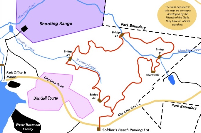
6.2 North Trail
- Hiking Distance: 2.5 miles
- Trail Length 2.3 miles
- Rating: Easy
- Trailhead GPS Coordinates: 35.899123, -85.088388
Driving Directions
To get to Meadow Park take Lantana Road, Highway 101, south out of Crossville. After about 3.5 miles, go straight through the lights where Highway 282 turns off for Lake Tansi. The road narrows from four lanes down to two lanes. After another mile turn right on to City Lake Road. There is a large Meadow Park sign on the corner. The trail-head parking is about half a mile on the left but you might want to follow City Lake Road to where it dead-ends at the park marina and office. Enjoy the views across the lake, and maybe use the restrooms at the campsite. Feel free to stop in the office and say “Hi” to the park manager, then drive back up the entrance road 0.6 miles to the trail-head parking lot which will now be on the right hand side of the road.
Description
By: Stella M. Gonzales-Woodworth
June 13, 2026
Discover one of Crossville’s newest outdoor treasures on the beautiful Meadow Park North Trail, completed in August 2024. This easy and inviting 2.5-mile loop trail begins at the Soldier’s Beach Trail parking lot. Simply cross the road and follow the trail sign into a peaceful woodland setting. After approximately 0.3 miles, hikers reach the beginning of the loop where they may choose to travel either clockwise or counterclockwise, entering a flexible and enjoyable hiking experience.
Winding through the scenic forests and natural landscapes, the trail offers a relaxing escape into nature for hikers of all ages and abilities. The gently rolling terrain makes it an excellent choice for families, casual walkers, runners, and anyone seeking a refreshing outdoor adventure. Along the route, several charming wooden bridges span small creeks and low-lying areas, adding both beauty and character to the hike.
Thoughtfully placed benches on strategic locations at the trail invite visitors to pause, rest and fully appreciate the peaceful surroundings. These quiet resting spots provide wonderful opportunities to take in the beauty of the forest, listen to birdsong, observe local wildlife, or simply enjoy a moment of reflection beneath the canopy of trees. Whether taking a brief break or lingering to enjoy the scenery, the benches enhance the trail’s welcoming and accessible nature.
As you stroll beneath the shade of towering hardwoods, you’ll experience the sights and sounds of the Cumberland Plateau’s natural beauty. Wildlife sightings, birds tweeting, and seasonal wildflowers enhance the experience, making every visit unique. Whether you’re looking for a peaceful morning walk, an afternoon family outing, or a place to reconnect with nature, Meadow Park North Trail provides the perfect setting.
Beyond its scenic appeal, the trail offers valuable health and wellness benefits. Walking in nature promotes cardiovascular health, improves balance and endurance, reduces stress, and supports mental well-being. The easy-to-follow path and gentle terrain make it ideal for people of all ages seeking healthy outdoor recreation in a beautiful natural environment.
Take a walk, breathe in the fresh air, and discover the tranquility of Meadow Park North Trail – a welcoming destination where nature, recreation, wellness and the beauty of nature of the forest come together in the heart of Crossville.