Hiking in Cumberland Mountain State Park
2. Cumberland Mountain State Park
Cumberland Mountain State Park began as part of the greater Cumberland Homesteads Project, a New Deal-era initiative by the Resettlement Administration that helped relocate poverty-stricken families on the Cumberland Plateau to small farms centered on what is now the Cumberland Homestead community. This 1,720-acre park was acquired in 1938 to provide a recreational area for some 250 families selected to homestead on the Cumberland Plateau.
You can find out more about hiking in the State Park at their website: Here
Hikes in Cumberland Mountain State Park
2.1 Pioneer Short Trail
- Hiking Distance: 1.8 mile
- Trail Length: 1.8 miles
- Rating: Easy
- Trailhead GPS Coordinates: 35.898570, -85.000284
Driving Directions
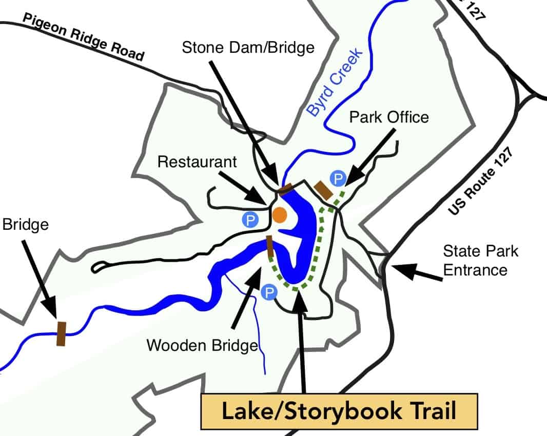
The Cumberland Mountain State Park is very well known and there are plenty of road signs directing you to the park, which is about four miles south east of Crossville on Highway 127. We suggest you park near the kayak marina behind the restaurant.
Description
By: Stella M. Gonzales-Woodworth, June 12, 2026
The Pioneer Short Loop Trail in Cumberland Mountain State Park, located in Crossville, Tennessee, is one of the area’s most scenic and enjoyable hiking destination. Following the peaceful waters of Byrd Creek, this trail offers hikers a perfect blend of natural beauty, unique rock formations, towering trees, and abundant wildlife. After turning left at the swinging bridge, crossing it, and continuing left along the loop, visitors are rewarded with some of the trail’s most memorable features.
Throughout the route, impressive sandstone outcroppings line the trail, creating a rugged mountain landscape that contrasts beautifully with the surrounding forest. Tall hardwoods and stately pines rise overhead, providing shade during warmer months and adding to the trail’s peaceful atmosphere.
Nature enthusiasts will appreciate the variety of wildlife frequently seen along the trail. Playful squirrels dart among the trees while songbirds fill the forest with their melodies. Seasonal wildflowers add splashes of color along the path, and observant hikers may spot other native wildlife quietly moving through the woods. The soothing sound of Byrd Creek flowing nearby enhance the tranquil experience.
The trail has historically featured numerous exposed roots that required careful footing. Today, dedicated Friends of the Trails volunteers are actively working to improve the walking and hiking paths through ongoing uprooting, leveling, and trimming efforts. Their commitment is constructing, maintaining and making the paths safer and more accessible for hikers of all ages and skill levels while preserving the trail’s natural character.
The Pioneer Short Loop Trail is also an excellent destination for dog owners. The wide variety of scenery, shaded pathways, and creekside views make it a favorite walking area for well-behaved leashed dogs and their owners seeking a relaxing outdoor advanture.
The scenic wooden swinging suspension bridge is undoubtedly the signature attraction of the Pioneer Short Loop Trail. Gracefully spanning Byrd Creek, the rustic bridge offers visitors a memorable experience as it gently sways beneath their feet, creating a sense of adventure while immersing them in the natural beauty of the park. As hikers cross the bridge, they are rewarded with continuous quaint views of Byrd Lake, whose calm waters reflect the surrounding hardwood forests and seasonal colors.

2.2 Pioneer Long Trail
- Hiking Distance: 2.6 miles
- Trail Length: 2.6 miles
- Rating: Moderate
- Trailhead GPS Coordinates: 35.893291, -85.025355
Description
Cross the road and walk back to the bridge. You can start the hike on either bank of the creek, The trail follows the creek for about 1.25 miles to a swinging bridge. Cross the bridge and return on the other bank of the creek to the trail-head.
This trail has many exposed roots on the trail so take extra care to avoid turning an ankle. The trails in the park pass close to water and there are steep drop-offs in many places so children should be supervised.
Driving Directions
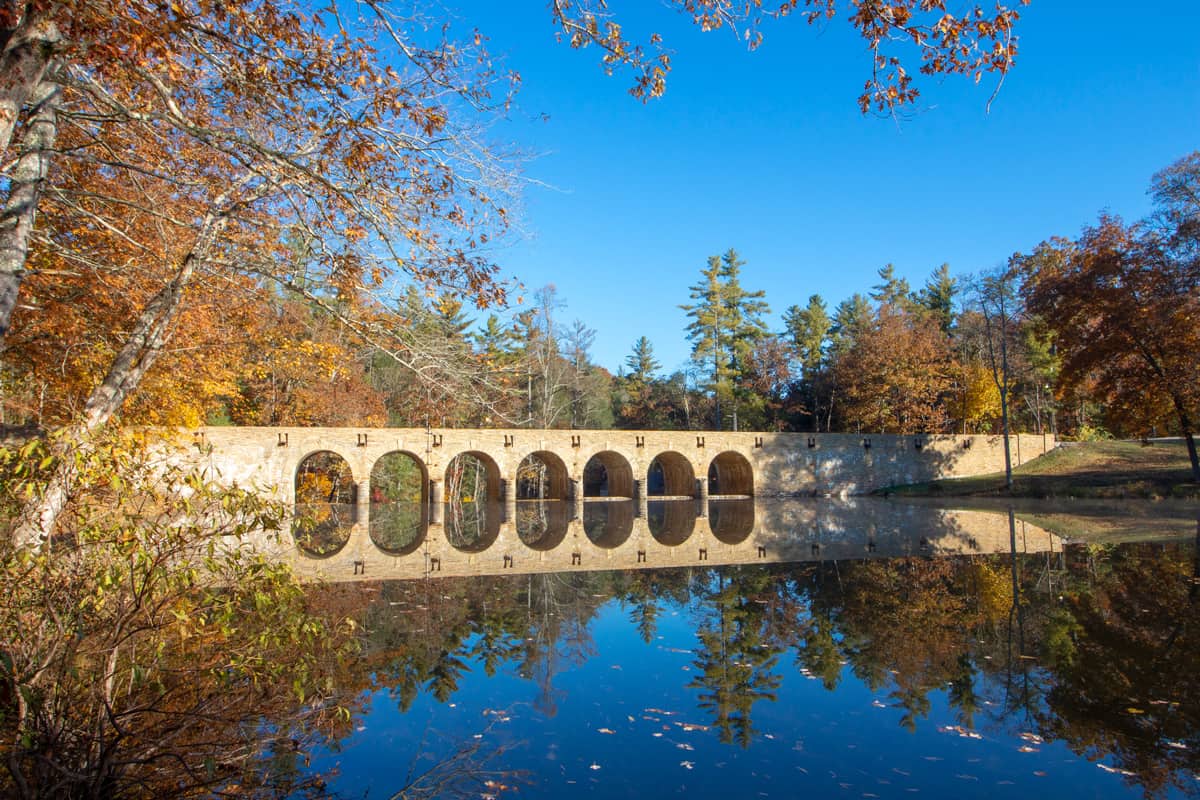
The Cumberland Mountain State Park is very well known and there are plenty of road signs directing you to the park, which is about four miles south east of Crossville on Highway 127. However do NOT enter the park in the usual entrance.Keep going on Route 127 South. Go Past the entrance to Bear Trace Golf Course. About 0.25 miles past Bear Trace turn right on to South Old Mail Road and follow the road for 1.8 miles to the stone bridge across Byrd Creek. Immediately after the bridge look for parking space on the left.(There is room for half-a-dozen vehicles along the road.) Please park head-on into the side of the road rather than parallel park so that more vehicles can fit in the limited space.

2.3 Byrd Creek Trail
- Hiking Distance: 2.6 miles
- Trail Length: 2.5 miles
- Rating: Easy
- Trailhead GPS Coordinates: 35.898570, -85.000284
Description
This trail follows along the banks of Byrd Creek for the entirety of the hike. At approximately one and a half miles hikers will come to the red and yellow junction. From here you should follow the red trail back to the CCC dam, then walk across the dam back to the park office where you started. This trail provides hikers with a unique tree top canopy of hemlock trees in several sections. Through these sections you will notice less vegetation on the forest floor and cooler temperatures in these areas. Hikers will also cross a small creek that is home to a very unique bridge that was built by an eagle scout.
Driving Directions
The Cumberland Mountain State Park is very well known and there are plenty of road signs directing you to the park, which is about four miles south east of Crossville on Highway 127. We suggest you park near the kayak marina behind the restaurant.

2.4 Byrd Lake ADA Trail (Paved)
- Hiking Distance: 1.5 miles/2.4 km (round-trip)
- Trail Length: 0.75 miles
- Rating: Easy
- Trailhead GPS Coordinates: 35.898506, -85.000298
Driving Directions
From US-70 take Hwy 127 in downtown Crossville. Turn left onto US-127 S (S. Main Street). On US-127 S, drive four miles until TN-419 N. Turn right onto TN-419 N and drive 0.4 miles to the park entrance. Park near the boat dock behind the restaurant and walk across the wooden bridge.
Trail Description by Stella M. Gonzales-Woodworth
June 5, 2026
Nestled along the tranquil shores of Byrd Lake in Cumberland Mountain State Park, the Storybook Paved Trail offers one of the most delightful and accessible outdoor experiences in Tennessee. Dedicated on September 14, 2018, this scenic 1.5-mile trail is the newest addition to the park and has quickly become a favorite destination for families, nature lovers, seniors and visitors of all abilities.
Designed to be fully compliant with the Americans with Disabilities Act (ADA), the trail features innovative flexible porous pavement that provides a smooth and comfortable surface for wheelchairs, strollers, walkers and hikers alike. Whether you are enjoying a leisurely stroll or exploring the park with young children, the Storybook Paved Trail welcomes everyone to experience nature together.
What makes this trail truly unique is its enchanting Storybook Trail concept. As visitors walk along the path, they encounter pages of a children’s story displayed at intervals, transforming an ordinary walk into an engaging literary adventure. This initiative is part of a partnership between the Governor’s Early Literacy Foundation and Tennessee’s State Parks, encouraging families to combine reading, learning and outdoor recreation.
The trail meanders through beautiful lakeside scenery, offering stunning views of Byrd Lake and abundant opportunities for wildlife observation. Visitors often spot graceful herons, playful ducks, and majestic geese gliding across the water. Comfortable benches placed throughout the trail invite hikers to pause, relax, and enjoy the peaceful surroundings. A charming green bridge adds a picturesque touch and serves as a favorite photo spot for families.
Adding to its convenience, a beautiful wooden bridge connects the Storybook Paved Trail to the park’s parking area and restaurant, making access easy for visitors of all ages and mobility levels. To preserve the trail’s peaceful atmosphere and ensure the safety of walkers, wheelchairs, and young children, bicycles are not permitted on the trail.
Whether you are seeking a gentle walk, a meaningful family outing, a birdwatching adventure, or an accessible nature experience, the Storybook Paved Trail offers a memorable journey where stories, wildlife, and natural beauty come together for visitors of all ages.
2.5 Overnight Trail
- Hiking Distance: 8.6 miles
- Trail Length: 6.0 miles
- Rating: Easy
- Trailhead GPS Coordinates: 35.898570, -85.000284
Note: The Overnight Trails is 6 miles but there is no trailhead parking. If you park by the boat dock then hike into the Overnight trail, and back, on the Byrd Creek Trail, this adds another 2.6 miles to the hike.
Description
This trail is accessed by hiking the Bryd Creek Trail to the blue and yellow junction. From here the overnight trail begins; a six mile loop trail that provides hikers with a dense forest surrounding them. The forest is made up of mostly oaks, hickory, sourwood, black gum, Virginia pine and white pines. You should be prepared to cross a swinging bridge and several creeks and streams along this loop trail. In the late spring, the overnight trail is home to a grove of pink lady’s slippers. The overnight campsite is located on this trail. Please register at the park office before camping.
Driving Directions
The Cumberland Mountain State Park is very well known and there are plenty of road signs directing you to the park, which is about four miles south east of Crossville on Highway 127. We suggest you park near the kayak marina behind the restaurant.

2.6 Pioneer Short & Byrd Lake ADA Trail (Paved)
- Hiking Distance: 2.8 miles
- Trail Length: 2.8 miles
- Rating: Easy
- Trailhead GPS Coordinates: 35.898570, -85.000284
Description
This hikes starts with doing the Pioneer Short Trail(1.8 miles) then walk the Byrd Lake paved trail to the park office (stop in at the gift shop) and back (1.0 miles). The Pioneer Short Trail has many exposed roots on the trail so take extra care to avoid turning an ankle. The trails in the park pass close to water and there are steep drop-offs in many places so children should be supervised.
Driving Directions
The Cumberland Mountain State Park is very well known and there are plenty of road signs directing you to the park, which is about four miles south east of Crossville on Highway 127. We suggest you park near the kayak marina behind the restaurant.
2.7 Pioneer Short & Long Trails
- Hiking Distance: 4.4 mile
- Trail Length: 4.4 miles
- Rating: Easy
- Trailhead GPS Coordinates: 35.898570, -85.000284
Description
The Pioneer Trail starts and ends at the wooden bridge. Follow the Pioneer Trail along the north bank (cabin side) of Bryd Creek to the swinging bridge. Continue onto the Pioneer Long Trail to Old Mail Road.
Go up onto the road and cross over the Creek on the stone bridge. Head back on the Pioneer Long Trail on the other side of the creek. When you reach the swinging bridge continue on to the Pioneer Short Trail to the wooden bridge. Cross over the bridge and return to your vehicle.
Driving Directions
The Cumberland Mountain State Park is very well known and there are plenty of road signs directing you to the park, which is about four miles south east of Crossville on Highway 127. We suggest you park near the kayak marina behind the restaurant.
