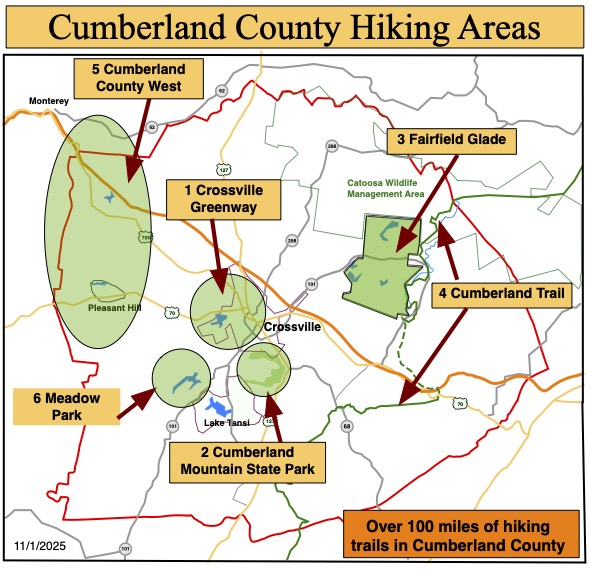
Maps, Maps and more Maps
The Trails of Cumberland County
As you hike these trails you will enjoy a wide variety of terrain and geographical features. We hope these trails take you places that you would not normally go and that you have positive experiences along the way. We hope you enjoy hiking these trails but please stay on the trail when hiking and respect private property in residential communities. Carry plenty of water at all times, use bug-spray and watch your step – it is easy to twist an ankle on rocks and tree roots. Pets are permitted on (nearly) all trails but please pick up after your dog if it fouls the trail-bed.
Interactive Map of County Trails
This is a new feature we are trying out. Let us know what you think.
We have created a Google “My Map” of Cumberland County and added many of the trails as GPX tracks. We think this is a useful feature as it allows you to zoom in on the trail, get driving directions and use other common features of Google maps. We will be adding more trails and features.
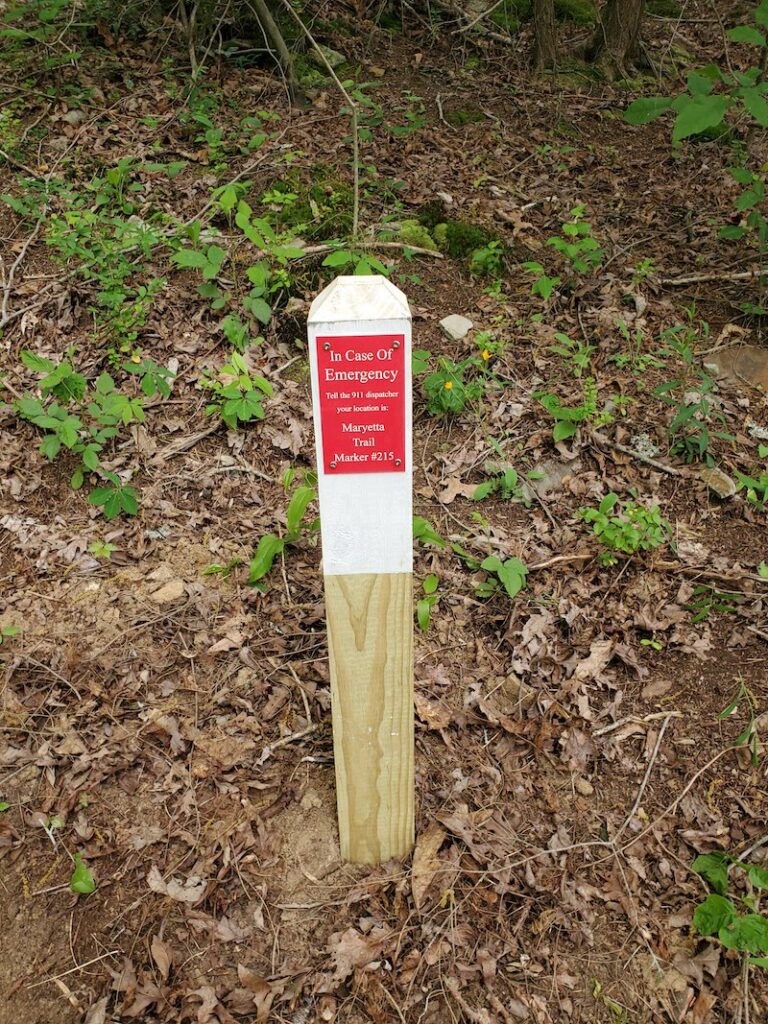
E911 markers are installed at one third of a mile intervals on most trails and this map shows the location of all markers on trails with Cumberland County.
Static PDF Map
Table of Contents
The Trails of Fairfield Glade
- Amherst Trail
- Blue Hike
- Central Trail
- Glastowbury Trail
- Good Samaritan Trail
- Green Hike
- Hemlock Trail
- Kirkstone Trail
- Library Trail
- Overlook Trail
- Red Hike
- Rotherham Trail
- Seven Bridges Trail
- Stonehenge Trail
- Thornhill Trail
- Yellow Hike
The Trails of Cumberland Mountain State Park
- Byrd Creek Trail
- Overnight Trail
- Pioneer Long Trail
- Pioneer Short & Storybook Paved Trail
- ADA Storybook Paved Trail
Table of Contents
The Crossville Greenway
Airport Trails
- Distance: North Trail 2.3 miles
- Distance: South Trail 2.5 miles
- Rating: Moderate
- Trailhead GPS Coordinates: 35.946734, -85.093314
- Link to GPS Track
Description
NOTE: The Airport Trail parking lot is used as the trail-head for both the North and South Trails.
The North Trail takes you through the “deserts” and along the airport perimeter fence for views of aircraft taking off and landing.
The South Trail is Crossville’s newest trail, completed in July 2024. It is a very pleasant walk trough the woods but with very few natural featues along the way.
Driving Directions:
Note: with bridge construction on Sparta highway there are detours in place.
From Crossville, take Sparta Highway from the Kroger store. Head west for three miles, past the airport termial building and runway. At the end of the runway turn left, just before the recycling center and almost immediately turn left again on to Earl Jones Roard. After about a quarter of a mile you will see the trailhead parking lot on the left.
Centennial Park Trail
- Distance: 1.2 miles
- Rating: Easy
- Trailhead GPS Coordinates: 35.967940, -85.026750
- Link to GPS Track
Description
This is an easy 1.2 mile hike. It is mostly in the sun, so a morning hike is recommended. This hike will take you through and around the softball fields and past the horseshoe building. It then circles up past the dog parks and back to the parking lot.
- Park in the parking lot close to the dog parks. The starting point is at the small plaza where 3 flags are displayed. This is also the same lot used for the pickleball courts.
- The hike begins at the flags. Walk up the paved trail through the building and between the softball fields. Continue straight
- At the crosswalk, continue straight toward the restrooms and horseshoe building
- Just past there the trail begins to circle back
- In an eighth mile or so, take a right across the bridge. At the T-junction take a left toward the dog parks
- Follow the trail to the second dog park. Take the sharp left at the trash can to begin your return to the parking lot
- Cross the bridge and follow the path up to the starting point parking lot
Driving Directions
Centennial Park is located on Industrial Boulevard.
Habitat Trail
- Distance: 2.1 miles
- Rating: Easy
- Trailhead GPS Coordinates: 35.949616, -85.048862
- Link to GPS Track
Description
This trail opened in July 2022. The trail-head parking is on Deerfield Road. The trail starts across the road from the parking lot. This is an easy lollypop trail along the Obed River.
Head into the woods from the parking lot. Pass the start of the Town Branch Spur on the right. Keep going crossing the creek itself using stepping stones. Look for the large Hilltoppers Bridge on the left. Cross the bridge over Spiers Branch Creek and follow the trail for about half a mile along the Obed River. At the end of the trail is a short loop which you navigate before returning the way you came.
On the way back after crossing the Hilltoppers Bridge and stepping over the Town Branch creek, take the trail on the left and check out the Town Branch Spur. It is an additional 0.2 mile, each way in and out, spur trail We recommend that you take the time to check out this extra section of trail.
Driving Directions
Take Miller Avenue to the stop light at the TCAT college. Take 10th street alongside the college. Follow the road to the stop sign on Deerfield Road. Turn right and the trailhead parking lot will be on your left.
Maryetta Trail
- Distance: 1.7 miles
- Rating: Easy
- Trailhead GPS Coordinates:35.960250, -85.049983
- GAIA GPS Map Link >
Description
This is a brand new trail that has just opened in time for this year’s marathon. It is a 1.7 mile “lollipop” trail in the woods pretty close to downtown Crossville. One leg of the loop is along the Obed River. The return is higher up the hillside.
Driving Directions
Take Sparta Highway from West Avenue at Krogers. After half a mile turn right onto the driveway of the Crossville Wastewater Treatment Facility. Before reaching the gates, turn left on the gravel track down to the trail-head parking area.
Meditation Trail
- Distance: 1.0 miles
- Rating: Easy
- Street Address: 1038 Sparta Hwy, Crossville, TN
- Trailhead GPS Coordinates: 35.959534, -85.060152
- GAIA GPS Map Link >
Description
Please do not hike this trail on a Sunday morning as the parking lot will be full with the congregation’s cars. Enter the Meditation Trail and enjoy an easy walk in this quiet spot close to the bustling activity in Crossville. As you walk over the bridge you can visualize how much water gets in the creek after heavy rain…..enough to wash this bridge away three times in recent months!
Driving Directions
Head out of Crossville along Sparta Highway, Route 70. After three quarters of a mile pass Ace Hardware on the right. Approximately a quarter of a mile after Ace turn right into the parking lot of the St Raphael Episcopal Church. Park behind the church close to the trailhead.
Obed River Park Trail
- Distance: 1.7 miles
- Rating: Easy
- Trailhead GPS Coordinates: 35.9744077, -85.046567
- GAIA GPS Map Link >
Description
This is an easy 1.7 mile trail that is shaded for about ½ the hike. Along the hike you will see the Obed River, the failed G.E. Harrison and J. Ridley Mitchell Dam, the location of the closed Tennessee Central Railroad Trestle and Corridor, and many Bluebird houses.
- Park in the second parking lot on the left (third entrance) after turning into the Obed River Park
- Look for the sign marking the trailhead toward the left
- Follow the paved trail along the river
- In about a half mile the trail turns up the hill at the failed G.E. Harrison and J. Ridley Mitchell Dam
- Continue up to the field and continue on the paved trail for about another quarter mile
- Take the first paved trail to the right
- From here you will hike the entire loop around the field to return to this intersection
- The second time around the loop you will take the next right down the hill
- Continue on the paved trail until you come to a parking lot
Plantation Trail
- Distance: 3.6 miles
- Rating: Easy
- Trailhead GPS Coordinates: 35.973718, -85.044335
- GAIA GPS Map Link >
Description
****Trail Closed***
This trail is closed due to excessive overgrown vegetation along the trail.
==================
The trailhead is in the second parking lot. The route passes along the paved trail towards the old dam on the Obed River, turn left onto the dirt Plantation trail. Enjoy this trail as it winds along the Little Obed River. At the end of the trail retrace your steps back to paved trail and return along the Obed River to the trail-head.
Driving Directions
Head out of Crossville on Route 70N, West Avenue, after 1.5 miles from the Kroger’s Plaza, turn right into the Obed River Park. Take the third turn on the left into the parking lot which is the trail-head.
TCAT Trail
- Distance: 0.5 miles
- Rating: Easy
- Trailhead GPS Coordinates: 35.945185, -85.035752
- GPS Track Link >
Description
This short 0.5 mile trail has been constructed mainly for the use of the college students and staff but it is open to the public. It is an easy trail that offers a calm walk in the woods.
Driving Directions
Parking for this short trail is in the GarrisonPark parking lot at the corner of Miller Avenue and 4th Street in downtown Crossville. Please do not park in the college student parking lots as spaces are very limited.
Woodlawn Loop Trail
- Distance: 1.2 miles
- Rating: Easy
- Trailhead GPS Coordinates: 35.974659, -85.025064
- GAIA GPS Map Link >
Description
This is a delightful figure-of-eight woodland trail that was constructed in 2017. Part of the trail is along the Little Obed River but you only get glimpses of the river as you pass close by.
Woodlawn Loop & Little Obed Trail
- Distance: 1.2 miles + 1.8 miles
- Rating: Easy
- Trailhead GPS Coordinates: 35.974659, -85.025064
- GAIA GPS: Woodlawn Loop >
- Gaia GPS: Little Obed>
Description
This is a delightful figure-of-eight woodland trail that was constructed in 2017. Part of the trail is along the Little Obed River but you only get glimpses of the river as you pass close by.
To hike the Little Obed Trail, constructed in 2020, you will start off by taking the Woodlawn loop trail from the trail-head parking lot. Turn right at the first junction in the woods. A short distance later turn right again to get on to the Little Obed Trail. It is a nice easy trail that gets closer to the river in places. The trail ends at Old Jamestown Highway. Eventually we hope to continue the trail on the other side of the road but for now we recommend that you turn around when you see the road and return to the trail-head where you started.
Cumberland County trails
Gateway Trail (Meadow Creek Park, Monterey)
- Distance: 3 miles
- Rating: Easy
- Trailhead GPS Coordinates: 36.115286, -85.187851
- Google GPS Map Link >
Description
Meadow Creek Park is a multi-use recreational park that is being developed, by the town of Monterey for mountain biking, hiking, fishing, kayaking, etc. There are many trails in the park but they are primarily biking trails but hikers are welcomed. A trail all around the lake is under construction.
NOTE: Take care and watch out for mountain bike riders while on the trail…especially if you have a dog on a leash.
The Hiking Marathon Gateway Trail is one of the trails that is a relatively easy hike with a short section around halfway that is rather steep. Navigate carefully by following the red arrows
Driving Directions
From Crossville, take Highway 70 North to Monterey. In Monterey turn right on to South Holly Street for four or five blocks before turning right on to East Commercial Street (which is Monterey’s “Main St.” where you can find a few stores and restaurants).Stay on E Commercial St, which becomes Clark Range Highway, for five miles. You will see the entrance to Meadow Creek Park on the right. Go to the end of the gravel road, about a third of a mile, to the trailhead parking lot that is shared with fishermen and kayakers.
Soldier's Beach Trail (Meadow Park, Crossville)
- Distance: 1.7 miles
- Rating: Easy
- Trailhead GPS Coordinates: 35.899123, -85.088388
- Google GPS Map Link >
Description
It is recommended that you follow the signs and hike this 1.7-mile trail in a counter-clockwise direction. It is a very pretty trail with not many uphill sections to be negotiated and many views across the lake. The trail does pass close to the lakeshore so children do need to be supervised.
Note: This is called Soldier’s Beach Trail because, during World War 2, German Prisoners of War from a camp in Crossville were used to build a recreational facility here for US Soldier’s families. Although it does not mention Soldier’s Beach you can learn more about the POW camp in this magazine article.
Driving Directions
To get to Meadow Park take Lantana Road, Highway 101, south out of Crossville. After about 3.5 miles, go straight through the lights where Highway 282 turns off for Lake Tansi. The road narrows from four lanes down to two lanes. After another mile turn right on to City Lake Road. There is a large Meadow Park sign on the corner. The trail-head parking is about half a mile on the left but you might want to follow City Lake Road to where it dead-ends at the park marina and office. Enjoy the views across the lake, and maybe use the restrooms at the campsite. Feel free to stop in the office and say “Hi” to the park manager, then drive back up the entrance road 0.6 miles to the trail-head parking lot which will now be on the right hand side of the road.
NorthTrail (Meadow Park, Crossville)
- Distance: 2.5 miles
- Rating: Easy
- Trailhead GPS Coordinates: 35.899123, -85.088388
- GPS Track Link >
Description
This is a new trail that was completed in August 2024. The trail-head is the Soldier’s Beach parking lot. Cross the road and follow the sign entering into woods. After 0.3 miles the trail splits. This is the start of the loop so you can go either clockwise or counterclockwise around the loop.
Driving Directions
To get to Meadow Park take Lantana Road, Highway 101, south out of Crossville. After about 3.5 miles, go straight through the lights where Highway 282 turns off for Lake Tansi. The road narrows from four lanes down to two lanes. After another mile turn right on to City Lake Road. There is a large Meadow Park sign on the corner. The trail-head parking is about half a mile on the left but you might want to follow City Lake Road to where it dead-ends at the park marina and office. Enjoy the views across the lake, and maybe use the restrooms at the campsite. Feel free to stop in the office and say “Hi” to the park manager, then drive back up the entrance road 0.6 miles to the trail-head parking lot which will now be on the right hand side of the road
Uplands Village Trails (Pleasant Hill)
- Distance: 1.5 miles, 1 mile & 0.3 miles
- Rating: Combination of Easy and Moderate
- Trailhead GPS Coordinates: 35.982905, -85.203718
- Google GPS Map Link >
Description
The Uplands Village Trails are three trails with their trail-heads within walking distance of each other.
The Lake Alice Trail has been on the marathon a few times in the past and is a pleasant hike around the lake. This year we are adding the Frey Branch Trail which is a one-mile trail through some steep and rocky terrain in the woods. The Lake Laura ADA Trail is a very short trail.
NOTE: When walking on West Lake Road between trails or parking, walk on the shoulder on the west side of West Lake. The shoulder is wider there and safer around the blind curve.
Driving Directions
The Lake Alice Trail is in Uplands Village, Pleasant Hill. Take the Sparta highway from Crossville for 10 miles then, shortly after passing a gas station on the left, take the right turn on East Main Street into the village. Pass the Elementary School and a short distance later turn right on to West Lake Road. After about half a mile pull over to the left onto Yonside Drive and immediately left again into the gravel trailhead parking from where you can access all three trails.
NOTE: Yonside is a one way street. However it is acceptable to enter Yonside the wrong way for the very short distance to the parking lot.
Fairfield Glade Trails
All the trails in Fairfield Glade can be found on their own website at www.gladetrails.com
- Amherst Trail
- Blue Loop
- Central Trail
- Good Samaritan Trail
- Green Loop
- Hemlock Trail
- Kirkstone Trail
- Library Trail
- Overlook Trail
- Red Loop
- Rotherham Trail
- Seven Bridges Trail
- Stonehenge Trail
- Thornhill Trail
- Yellow Loop
Cumberland Mountain State Park Trails
The Cumberland Mountain State Park has it’s own website. There are maps here of the trails that have featured in the Hiking Marathon.
- Byrd Creek Trail
- Overnight Trail
- Pioneer Long Trail
- Pioneer Short & ADA Paved Trail
Pioneer Long Trail
- Distance: 2.5 miles
- Rating: Easy
- Trailhead GPS Coordinates: 35.893291, -85.025355
- GAIA GPS Map Link >
Description
Cross the road and walk back to the bridge. You can start the hike on either bank of the creek, The trail follows the creek for about 1.25 miles to a swinging bridge. Cross the bridge and return on the other bank of the creek to the trail-head.
This trail has many exposed roots on the trail so take extra care to avoid turning an ankle. The trails in the park pass close to water and there are steep drop-offs in many places so children should be supervised.
Driving Directions
The Cumberland Mountain State Park is very well known and there are plenty of road signs directing you to the park, which is about four miles south east of Crossville on Highway 127. However do NOT enter the park in the usual entrance.Keep going on Route 127 South. Go Past the entrance to Bear Trace Golf Course. About 0.25 miles past Bear Trace turn right on to South Old Mail Road and follow the road for 1.8 miles to the stone bridge across Byrd Creek. Immediately after the bridge look for parking space on the left.(There is room for half-a-dozen vehicles along the road.) Please park head-on into the side of the road rather than parallel park so that more vehicles can fit in the limited space.
Pioneer Short & ADA Paved Trail
- Distance: 3.2 miles
- Rating: Easy
- Trailhead GPS Coordinates: 35.900761, -84.997164
- GAIA GPS Map Link >
Description
Cross the park road to the start of the ADA Paved Trail. Follow the paved trail to the wooden bridge where the Pioneer Trail starts and ends. Follow the Pioneer Trail along Bryd Creek then cross the creek on the swinging bridge and return on the other side of the creek.
This trail has many exposed roots on the trail so take extra care to avoid turning an ankle. The trails in the park pass close to water and there are steep drop-offs in many places so children should be supervised.
Driving Directions
The Cumberland Mountain State Park is very well known and there are plenty of road signs directing you to the park, which is about four miles south east of Crossville on Highway 127. We recommend parking by the park office.
ADA Storybook (Byrd Lake) Paved Trail
- Distance: 1.2 miles (round-trip)
- Rating: Easy
- Trailhead GPS Coordinates: 35.898506, -85.000298
- GAIA GPS Map Link
Description
This trail is 0.6 miles in length giving a 1.2 mile roundtrip hike. Start at the kayak marina behind the restaurant. Cross the wooden bridge onto the Storybook Trail. Stop along the way and read the kid friendly signs. When you reach the road by the Park Office turn around and return. (There are public restrooms in the park office building and the restaurant.)
Driving Directions
The Cumberland Mountain State Park is very well known and there are plenty of road signs directing you to the park, which is about four miles south east of Crossville on Highway 127.
There is plenty of parking in the park but please do not park in the restaurant parking lot as that gets very busy at times. We suggest you park near the kayak marina behind the restaurant.
Cumberland Trail Sections
CT Black Mountain Summit Crest Loop
- Distance: 2.0 miles
- Rating: Moderate
- Trailhead GPS Coordinates: 35.868440, -84.887748
- Google Trail Map Link >
Description
After parking the car, follow the signs to the Main Trail and the South Overlook. After enjoying the views at the overlook return to the Main Trail and head south along this section of the Cumberland Trail. You can take the staircase down off the summit if you want to admire the rock formations, then back up the stairs and turn left onto the loop trail to the northern overlook (which is overgrown and not very impressive). Continue along the loop trail, crossing over the access road. Note where the main, Cumberland Trail branches off the left but remain on the loop trail and return to the parking lot. The trails in the park pass close to steep drop-offs in many places so children should be supervised.
Driving Directions
Take Bat Town Road south from the Crab Orchard exit from I-140, Exit 329. After about two miles turn left onto Owl Roost Road where it is signed to the Justin P Wilson State Park. Take Owl Roost Road and Black Mountain Road for three miles to the parking lot at the summit of the mountain. Drive carefully as it is a single-track road with few passing places.
CT Head of Sequatchie Trail
- Distance: 3.2 miles
- Rating: Moderate
- Trailhead GPS Coordinates: 35.793145, -85.009060
- GPS Track Link
ABOUT THE HEAD OF SEQUATCHIE
The Head of Sequatchie is an area of the Justin P. Wilson Cumberland Trail State Park admired for its serenity and beauty. Named for the headwaters of the Sequatchie River, the Head of Sequatchie boasts hiking, history, and pristine beauty serving as a snapshot of a time since passed.
Enjoy the birthplace of the Sequatchie River, which rushes forth as the only natural water outlet of the pristine Grassy Cove to the north as a result of the karst topography of the area. Take the side trail to an overlook of Devilstep Hollow Cave and pass by Sherrill Cemetery where rests the first sheriff of Cumberland County–Craven Sherrill (descendant of Katherine “Bonnie Kate” Sherrill, wife of John Sevier).
On these grounds, you will walk the same trails as the first European settlers of Tennessee as well as Native Americans dating back to the Mississippian Period when Devilstep Hollow Cave was an important ceremonial site (home to some of the most archaeologically significant pictographs, petroglyphs, and mud glyphs in the southeastern United States).
The beginning of the Sequatchie Valley, which stretches into Alabama, is an excellent place for picnics, outings, and gatherings of all sorts. Accessible and open to all–The Head of Sequatchie is like no other.
Trail Description
Note: The Head of Sequatchie is only open for 9am to 5pm each day so please plan your hiking accordingly.
Park in the grassy area and walk across the bridge. Restrooms are in the first building across the bridge on the left. The trail begins across the field behind the building to the right. Cross the bridge where the Sequatchie River begins as a spring, cross the bridge and turn left and up the steps. Turn at the third left off of the grassy road (follow the Marathon arrows), and follow the trail through the woods for a while then retrace your steps to the grassy road and then turn left and follow the mowed field path back to the head of the Sequatchie river.
Note: This trail was on the 2022 Hiking Marathon.
Driving Directions
Driving from Crossville:
- Take Highway 127 south out of Crossville. After 2.4 miles you will come to a split, at the Homestead Tower, as highway 68 goes to the left you will take a right and stay on highway 127 south. After 0.6 miles you will pass the main entrance to Cumberland Mountain State Park. Stay on Highway 127 south. After 5 miles you will pass the Basses Creek Bridge.
- You should continue south on Highway 127. After you pass Basses Creek bridge start looking for a left turn onto Brown Road. This road is 1.6 miles from the bridge, just after you have topped a hill.
- Brown Road is a tar and chip road you will follow for 0.7 miles until it tees into Rhea Road, here turn to the left.
- You will follow Rhea road for about 0.5 miles until it tees at Old highway 28 at the dumpster station. Here you turn right and go south on old highway 28.
- Follow old 28 for a distance of 2.5 miles down off the Plateau as you begin your descent into the Sequatchie Valley. You will make two sharp turns going down, so watch your speed as the road is also narrow.
- Turn left at the Head of Sequatchie Sign, onto the gravel driveway that goes onto the park property.
- Follow this gravel road to the bottom of the hill to the parking area.
CT Ozone Falls Trail
- Distance: 2.0 miles
- Rating: Strenuous
- Trailhead GPS Coordinates:35.881485, -84.810211
- Link to GPS Track
Note 1: This trail is rather steep and rocky as it descends to the base of the falls. Take extra care especially, if the rocks are wet. Hiking poles will be very helpful on this trail.
Note 2: This is a State Natural Area and pets are prohibited……so leave your dogs at home when you hike this trail.
Description
You may want to go 100 yards to visit the top of the falls before you begin. The trail begins near route 70 and parallels the road for 50 yards before turning left and heading below the falls. There are many rock steps that lead you down. Follow the trail and at 0.2 mile follow the sign towards Black Mountain. At 0.5 mile you will cross a white bridge. At exactly 1 mile, turn around at the giant rock at the left side of the trail. and retrace your steps back to your car.
Driving Directions
From the Crab Orchard exit off I-40, exit 329, head east on Route 70 for 4.5 miles to the Ozone Falls State Natural Area. Park on either side of the road where parking is available being careful not to block roads or driveways.
CT Peavine-McGinnis Section
- Distance: 4.4 miles (round-trip)
- Rating: Moderate
- Rating: Moderate
- Trailhead GPS Coordinates: 36.000824, -84.825522
- GAIA GPS Map Link >
Description
Cross the road and follow the winding trail. After 1.3 miles the trail crosses an old gravel logging road and after 2.2 miles you reach the wooden bridge over McGinnis Creek. Stop, rest, have a drink, enjoy the rocks and vegetation, and then retrace your steps back to your car.
Driving Directions
This trailhead is exactly 3.0 miles from the corner of Peavine Road and Catoosa Blvd, (and Westchester Dr.) on Peavine Road in Fairfield Glade. Park on the right side of the road across from the trailhead.
CT Windlass Cave Section
- Distance: 3.0 miles (round-trip)
- Rating: Moderate
- Trailhead GPS Coordinates: 35.870433, -84.929764
- GAIA GPSl Map Link >
Description
Cross the road and start up the Black Mountain Trail. (Take care not to head south on the Brady Mountain Trail!) Hike trail steadily uphill for about one and a half miles to Windlass Cave. The cave iteself is closed to the public to protect the bats in the cave itself from the white-nose disease. Take a well-earned rest before turning around and heading back downhill to the trailhead to complete this 3.0-mile hike.
Driving Directions
Driving from Crossville: Take route 127 south. At the Homestead Tower leave route 127 and follow route 68 towards Grassy Cove and Spring City. After four miles pass Cox Valley Road on the left. Shortly afterwards identify the Brady Mountain trailhead parking on the right, just a shoulder along Route 68.